NWS Seattle (@NWSSeattle) header
NWS Seattle (@NWSSeattle) profile picture

Official Twitter account for the National Weather Service Seattle. Details: https://xitter.gq/t.co/yoQbjVwBSK

Seattle, WA
Joined July 2012
Photo by NWS Seattle (@NWSSeattle)Photo by NWS Seattle (@NWSSeattle)Photo by NWS Seattle (@NWSSeattle)Photo by NWS Seattle (@NWSSeattle)Photo by NWS Seattle (@NWSSeattle)Photo by NWS Seattle (@NWSSeattle)Photo by NWS Seattle (@NWSSeattle)Photo by NWS Seattle (@NWSSeattle)Photo by NWS Seattle (@NWSSeattle)Photo by NWS Seattle (@NWSSeattle)
10 AM Radar Update: Few showers will continue off and on today with a front moving through. Few areas will see breezy winds this morning with winds decreasing through the day. We'll get a break with the rain finishing the week after today. #wawx
1
3
1
37
5,190
A national test of the Emergency Alert System is planned for today at 11:20 AM PST. The test message will be distributed to the public via television and radio broadcasts - NOAA Weather Radios will not receive the test. If the test cannot proceed today, December 3 is the backup.
We’ve heard a lot of rumors about tomorrow’s EAS test. 📺📻 Let’s clear things up. It lasts 1 minute, and no action is required. No blackouts, no secret emergencies. Just our legally mandated, routine test on TV and radio at approximately 2:20 PM ET: fema.gov/press-release/20261…
2
15
4
76
19,017
Some lingering shower activity out there this evening, mostly along the coast & Olympic Peninsula. Showers will largely taper across the area into Tuesday for overall drier conditions, though some isolated activity will continue along the coast through Tuesday morning. #wawx
1
3
55
8,122
Latest satellite imagery shows the next weather system that will move onshore into tonight, bringing rain and locally gusty winds to the area! Rain showers will linger at times on Sunday, with a slight chance of thunderstorms as well, especially for the Olympic Peninsula. #WAwx
2
21
3
178
18,849
In case you heard otherwise, there is no radar outage and radar.weather.gov is fully operational! Outdated content from isolated webpages stating otherwise has been circulating, but NWS radars are operating normally.
207
3,359
439
15,140
1,414,859
1 pm temperatures already setting record highs across the area. Seattle 66 degrees ( old record 65 in 1990 ), Bellingham 68 degrees ( old record 67 in 1977 ), Olympia 66 ( old record 64 in 1990 ). #wawx
6
21
4
237
19,142
6 AM PST on the 11th of November and one of the warmest locations in the nation outside of Florida and Hawaii is.... Bellingham, Washington at 65° F. #wawx
22
103
30
1,951
77,648
NWS Seattle retweeted
An unsettled weather pattern will continue this week, with several #AtmosphericRivers forecast to impact the Pacific Northwest. Parts of the Olympic Peninsula may see 10+ inches of total precipitation. See our latest AR Outlook for more details: cw3e.ucsd.edu/cw3e-ar-outloo….
2
13
1
60
6,799
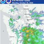
6:45 PM Update: Heavier rain is moving N into Puget Sound region this evening with a few isolated lightning strikes near Belfair. Other stronger clusters of rain are near Federal Way & Spanaway. These areas will have the best chances for additional lightning as they move NE #wawx
4
21
1
114
15,157
2:30 PM Radar Update: Rain will continue to pick up this afternoon and evening ahead of today's front moving through. Rain rates may become heavy at times and reduce visibilities, so use caution if commuting on the roads this afternoon and evening. #wawx
1
16
1
71
9,501
Scattered showers continue across W WA this morning. Isolated thunderstorms will be possible through this afternoon along the coast and for areas from Everett northward. Overall shower activity will decrease heading into this evening for a brief break in between systems. #wawx
1
15
93
10,234
A special weather statement has been issued for Aberdeen WA, Hoquiam WA and Ocean Shores WA until 11:00 PM PST
2
12
1
69
16,860
⚠️🍃Under strong winds consider delaying travel until winds subside. Once conditions have improved enough to resume traveling, stay alert for fallen tree limbs, road signs, or downed powerlines. #wawx
6
43
3
301
60,271
NWS Seattle retweeted
Winds, gusty rain, high-elevation snow and strong waves are all in the forecast tonight. Be prepared for downed power lines or fallen trees. Please watch out for crews as they work to clear roads quickly. You can track road closures on @wsdot Travel Map: wsdot.com/Travel/Real-time/M…
Southerly winds have started to pick up along the coast this afternoon & will pick up across Puget Sound this evening. Winds will peak overnight before easing Sunday AM. Wind gusts to 60 mph possible along the coast, with wind gusts to 50 mph possible across the interior. #wawx
1
6
2
20
7,100
NWS Seattle retweeted
NWS says we could see lots of rain and gusty winds across our region tonight. You might find downed trees and debris, darkened signals or power lines in the road. Conditions can change quickly. Be prepared, stay alert and watch for road crews #wawx
Southerly winds have started to pick up along the coast this afternoon & will pick up across Puget Sound this evening. Winds will peak overnight before easing Sunday AM. Wind gusts to 60 mph possible along the coast, with wind gusts to 50 mph possible across the interior. #wawx
1
7
2
29
8,264
Quick radar update as of 6:35 PM tonight. Peak wind at Hoquiam last hour of 69 mph. Many other sites into the 40 mph range including Bellingham, Friday Harbor, & Quillayute. Look for increasing winds through Puget Sound as this front advances east during next several hours.
5
36
5
228
22,215
Southerly winds have started to pick up along the coast this afternoon & will pick up across Puget Sound this evening. Winds will peak overnight before easing Sunday AM. Wind gusts to 60 mph possible along the coast, with wind gusts to 50 mph possible across the interior. #wawx
1
26
9
94
25,860
It's been a windy day across portions of western WA. Winds are favored to trend lighter tonight but the next system will arrive on Saturday with an additional round of gusty conditions leading into Sunday morning. #wawx
4
14
2
127
13,529
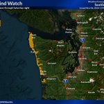
A High Wind Watch has been issued for the WA coast from Saturday afternoon through late Saturday night. South winds 25 to 35 mph with gusts up to 60 mph are possible. Damaging winds could blow down trees and widespread power outages are possible! #wawx
7
23
5,410
We're flipping the switch this week. 🌧️Rain chances will increase mid to late week as a series of weather systems moves into the area. With mostly dry conditions expected today & Tuesday, it's a great time to rake leaves & unclog your gutters and storm drains. #wawx
2
9
2
55
10,125