








The possible tropical development off the southeast U.S. coast that Google DeepMind had been hinting at for a few days already has now been officially marked by the National Hurricane Center.
An area of low pressure that will be developing later this week currently has a medium (40%) chance 🟠 of acquiring topical or subtropical characteristics over the weekend as it gradually moves to the northeast just offshore of the Eastern Seaboard of the U.S.
Next name up would be Kyle.

101
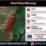
❗️Flash flood warning has been issued for this portion of Miami-Dade County.
📍Locations that will experience flooding:
Homestead, Black Point, Homestead Miami Speedway, Homestead Base, Princeton, Goulds, Cutler Bay, Homestead Bayfront Park and Palmetto Bay.
#FLwx

💨 Gusty conditions continue across South Florida today as a wind advisory has just been issued for coastal and metro Palm Beach, Broward, and Miami-Dade until 1AM Thursday. East winds will be sustained at around 25-30 mph with gusts of as high as 45 mph. Make sure to secure any loose outdoor items that may easily be blown away in the wind. #FLwx

150
We will do it all over again today, as widely scattered showers and thunderstorms are forecast to affect South Florida and at the same time, bring renewed rounds of heavy downpours to areas that were drenched yesterday. Provided is a high-resolution model simulation of how things could play out today with regards to shower/storm coverage and timing.
Guidance has the heaviest rainfall setting up over northern Broward and Palm Beach Counties today, with the most-likely scenario portraying a widespread 1-3 inches with isolated totals as high as 4-6 inches across this general area.
Worst-case scenario (1 in 10 chance of occurring) forecast, however, shows the potential for as much as 8-10 inches in isolated locations. Given the overall pattern we are in and that we already saw a similar situation pan out yesterday, it will not out of the realm of possibility for the atmosphere to pump out this much precipitation for a second consecutive day.
Stay out of floodwaters, remain vigilant, and stay safe during your commute today.
#FLwx


🚨 1-IN-50-YEAR RAINFALL EVENT: Playland Village in the Davie area (west of the Turnpike, north of Griffin Rd, and east of SW 64th Av) and Playland Estates in the Hollywood area (along and just south of Sheridan St and east of 441) have received 8.29” and 7.89”, respectively, of rain in just the past 3 hours.
These both qualify for a phenomenon known as a 1-in-50-year rainfall event, meaning that the aforementioned rainfall totals both locations received in just a short, 3-hour interval only has a 2% chance of occurring in any given year.
#FLwx

❗️We’ve seen nearly a foot of rain in Hollywood in the last 3-5 hours! You never truly know how deep floodwaters are, especially at night. Avoid driving through flooded roadways! #FLwx

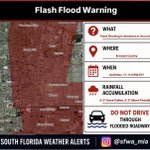
❗️Flash flood warning has been issued for this portion of Broward County.
📍Locations that will experience flooding:
Davie, Plantation, Sunrise, Weston, Sawgrass Mills Mall and Markham Park.
#FLwx

❗️Flash flood warning has been issued for this portion of Broward County.
📍Locations that will experience flooding:
Fort Lauderdale, Hollywood, Hallandale, Dania Beach, West Park, Estates Of Fort Lauderdale, Ravenswood Estates, Oak Point, Chambers Estates, Fort Lauderdale - Hollywood International Airport, Chula Vista, Washington Park, Pembroke Park, Intersection I-595 And I-95, Hollywood Downtown, Riverland Village and Boulevard Gardens.
#FLwx

811
❗️Flash flood warning has been issued for this portion of Broward County.
📍Locations that will experience flooding:
Pembroke Pines, Miramar, Cooper City, West Park, Royal Palm Ranches, Miramar Parkway And University Drive and Sunshine Acres.
#FLwx

❗️Flash flood warning has been issued for this portion of Broward County.
📍Locations that will experience flooding:
Hollywood, Davie, Plantation, Sunrise, Lauderhill, Cooper City, Nova Southeastern University, Pine Island Ridge, Broadview Park, Melrose Park, St. George, Washington Park, Chambers Estates, Downtown Davie and Broward Estates.
#FLwx

❗️Flash flood warning has been issued for this portion of Miami-Dade County.
📍Locations that will experience flooding:
Miami Gardens, North Miami, Opa-Locka, Hard Rock Stadium, Golden Glades, Westview and Saint Thomas University.
#FLwx

2
433
❗️Flash flood warning has been issued for these portions of Miami-Dade and Broward Counties.
📍Locations that will experience flooding:
Hollywood, Hallandale, North Miami, North Miami Beach, Aventura, Sunny Isles Beach, West Park, Ojus, Golden Glades, Pembroke Park, Golden Beach, Ives Estates, Hollywood Downtown and Fiu North Campus.
#FLwx

❗️Flash flood warning has been issued for this portion of Broward County.
📍Locations that will experience flooding:
Coral Springs, Tamarac, Margate, Lauderhill, Coconut Creek, North Lauderdale, Lauderdale Lakes, Parkland, Broadview-Pompano Park, Godfrey Road, Village Park, Palm Aire and Ramblewood East.
#FLwx

Flood advisory has been issued for these portions of Broward and Palm Beach Counties.
📍Locations that will experience flooding:
Pompano Beach, Boca Raton, Deerfield Beach, Margate, Lighthouse Point, Coconut Creek, Parkland, Hillsboro Beach, Boca Pointe, Boca Del Mar, Mission Bay, North Pompano Beach, Hillsboro Ranches, Pompano Beach Airport, Hillsboro Pines and Sandalfoot Cove.
#FLwx

1
6
656
⚠️ Heads up South Florida ⚠️
An approaching atmospheric disturbance is expected to bring a multi-day period of unsettled weather in which we could experience heavy downpours that ultimately lead to flash flooding. We are most likely to see widespread rainfall totals of 2-4 inches across the east coast, with isolated higher totals of 6-8 inches possible.
#FLwx

Temperatures this week won’t be quite as cool as they were this past weekend, but we will still be looking at values that are near average to a few degrees warmer than normal for this time of year. The breezy conditions we’re expecting this week will also make it feel a little cooler out, especially past sundown. #FLwx


103
Winds will begin to strengthen across South Florida tonight and will remain gusty through at least Thursday, bringing a prolonged period of beach and marine impacts. #FLwx

4
147
Is hurricane season over? It certainly seems that way for the time being with neither the National Hurricane Center (first image) or Climate Prediction Center (second image) monitoring any areas for tropical development over the next 7 days and through the end of the month, respectively.
Google DeepMind (third image) tries to develop something off the southeast U.S. coast between the 7 to 10 day timeframe, but currently has an extremely low probability (<10%) of occurring.


117
Good Sunday morning South Florida! After another chilly start to the day, temperatures will recover quite nicely this afternoon with highs that will not be as cool as yesterday but are still forecast to be a few degrees below average for this time of year. Many will be topping out in the mid to upper 70s in what should be another marvelous day with plenty of sunshine to bring our weekend to a close. #FLwx

127