

To save lives, protect property, and reduce the impacts of disasters through the mitigation, preparedness, response and recovery phases of Emergency Management.
Cowley County, Kansas
Joined February 2012
- Tweets9.8K
- Following57
- Followers1K
- Likes536





CowleyCountyEM retweeted

Other than some hit-or-miss showers and sprinkles this morning west of the Flint Hills, dry and seasonably warm weather will prevail through at least early next week. #kswx

CowleyCountyEM retweeted
Dry and quiet conditions continue into the weekend with highs in the 80s. #kswx


CowleyCountyEM retweeted
Dry and pleasant conditions continue into the weekend with highs in the low to mid 80s. (I think we're running out of ideas to say the weather will be quiet for awhile.) #kswx

ALT Friday, Saturday & Sunday: Highs ranging from 79 to 85 with sunny skies.
CowleyCountyEM retweeted
A weak cold front will knock temperatures into the 70s and low 80s for much of the area for Wednesday and Thursday. #kswx

ALT Wednesday and Thursday: Sunny skies and highs in the 70s and low 80s.
CowleyCountyEM retweeted
Sunny conditions with mild temperatures in the 80s are in store for the region this afternoon. #kswx

CowleyCountyEM retweeted
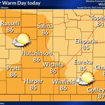
Sunny skies and temperatures in the 80s are in store for tomorrow. #kswx

ALT Sunny skies and temperatures in the 80s across the eastern half of Kansas on Tuesday.
CowleyCountyEM retweeted
Another day of record highs expected again on Tuesday afternoon for central and southeast Kansas. #kswx

CowleyCountyEM retweeted
Despite some lingering showers this morning, skies should clear out by early this afternoon. Highs should be in the low to mid 90s. #kswx

CowleyCountyEM retweeted
Hit-or-miss storms are possible from Friday evening through Saturday evening. Most across the area will not see rain, but the best chances will be along and north of I-70. #kswx

CowleyCountyEM retweeted
Scattered showers and a few thunderstorms are possible across south central KS this morning. Rainfall amounts will range from a trace to around a quarter of an inch. #kswx

CowleyCountyEM retweeted
Scattered showers and storms will impact mainly central Kansas this evening and tonight. Winds gusts up to 55 mph may accompany the strongest activity, along with locally heavy downpours. Rain chances drop off further east. #kswx

CowleyCountyEM retweeted
A few lingering thunderstorms are possible Saturday-Saturday night across central and north-central Kansas, but most locations should remain dry. Otherwise, well above average temperatures will prevail through Wednesday, with record highs possible! #kswx

CowleyCountyEM retweeted
Above normal temperatures are expected to remain for Wednesday as highs top out in the low 90s region wide. #kswx
CowleyCountyEM retweeted
Hot and dry weather will return tomorrow and should persist through the week. Thursday could be a tad cooler with some cloud cover possible. Overnight lows will generally be in the mid-60s through Thursday morning. #kswx
CowleyCountyEM retweeted
It was rather chilly this morning across the region, with some of the coolest temperatures since last May! Average overnight temperatures this time of year are in the low 60s. #kswx

CowleyCountyEM retweeted
Cooler air will overspread the region on Sunday with highs in the 70s. #kswx

CowleyCountyEM retweeted
Cooler air will spread southward across the region on Saturday along with chances of showers and storms mainly affecting central and south central Kansas. #kswx

CowleyCountyEM retweeted
A cold front will move through our area on Saturday bring much cooler air and chances for rain and storms behind the front. Widespread rain is not expected. Highs may struggle to hit 80 on Sunday making it a great day for outdoor activities. #kswx

CowleyCountyEM retweeted
Above normal temperatures are expected on Wed with mostly sunny skies. Patchy dense fog is possible across SE KS on Wed morning. #kswx
