Craig Solberg (@CraigSolberg) header
Craig Solberg (@CraigSolberg) profile picture

It's a dog-eat-dog world...and I'm wearing Milk-Bone underwear | John 8:32 | Philippians 4:6-7

Joined November 2012
Photo by Craig Solberg (@CraigSolberg)Photo by Craig Solberg (@CraigSolberg)Photo by Craig Solberg (@CraigSolberg)Photo by Craig Solberg (@CraigSolberg)Photo by Craig Solberg (@CraigSolberg)Photo by Craig Solberg (@CraigSolberg)Photo by Craig Solberg (@CraigSolberg)Photo by Craig Solberg (@CraigSolberg)Photo by Craig Solberg (@CraigSolberg)Photo by Craig Solberg (@CraigSolberg)
Craig Solberg retweeted
Did you know there are specific terms for weather fears? From Astraphobia (fear of thunderstorms) to Heliophobia (fear of the sun), weather can be a source of anxiety for many. Learn how to prepare for hazardous conditions at weather.gov/safety. #Halloween
8
2
24
6,268
For an area that quite often is begging for rain this time of year... #wheat
4
135
September temperature/rainfall rankings; warmest on record for the Nation #corn #soybeans #oatt
1
4
198
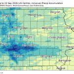
Getting mighty wet in the Corn Belt between Des Moines and Omaha...8.6" over the past week at Des Moines with radar estimating localized amounts of more than a foot this month #oatt #corn #soybeans
4
179
Worked with Steve with weather derivatives in 1999 He started at Canton Fitzgerald two weeks before 9/11 Finally got to pay my respects yesterday
1
6
Corn Belt August temps averaged 1.3°F above-normal; warmest since 2021. Summer (June-August) Corn Belt temps averaged 1.5°F above-normal; warmest since 2022 (tied). Summer of 2026 was the 9th consecutive year with above-normal summer temps in the Corn Belt #corn #soybeans #oatt
1
2
3
404
Abnormal summer warmth was entirely tied to lows...highs averaged 0.4°F above normal while lows averaged 2.7°F above-normal (tied with 2002/2016 as the 3rd warmest ever; behind only 2010 and 2011)...not since 2009 have summer overnight lows averaged below normal in the Corn Belt
1
2
163
Corn Belt rainfall in August was 0.92" above normal; wettest since 2018. Corn Belt summer rainfall ran 1.87" above-normal; compares with 2.90" above-normal for the summer of 2025 #corn #soybeans #oatt
2
251
Overnight lows today showed sub-70 readings for the first time since August 8 for a lot of the southwestern #corn belt (places like Des Moines, Omaha, Lincoln, Kansas City, Topeka)...low temperatures in that period among the 10 warmest on record...warmest ever in parts of MO
2
217
Intense t'storms impacted the Ohio Valley over the past few days, resulting in catastrophic flash flooding and major river flooding in Indiana. Additional rounds of t'storms are forecast through tonight. Here are some preliminary rainfall estimates and observations so far.
1
16
39
9,686
The MCS that moved from E IA to northern IN today has been preliminarily confirmed as a derecho. Based on the preliminary info thus far it began around 12Z this morning and continued to at least 1725 UTC. The max measured gust received thus far was 86 kts (99 mph) in Gary, IN
11
228
34
688
83,920
For the Nation as a whole...July was the hottest on record (beating out 1936)
1
4
290
July Corn Belt (productivity weighted) rainfall averaged 3.51"; 0.09" below normal (and compares with 5.86" in July of 2025)...first time since 2014 that July CB rainfall ran below normal #corn #soybeans
1
1
2
264
June-July Corn Belt rainfall averaged 8.57", 0.90" above-normal (11.01" in that period last year)
2
97
Corn Belt temperatures in July averaged 76.7°F, 2.3°F above normal to make it the 18th hottest on record (and the hottest July since 2012) #corn #soybeans
1
2
4
290
For the June-July period, Corn Belt (production weighted) temperatures averaged 73.8°F, 1.8°F above-normal (24th warmest on record). Last year that period averaged 74.2°F.
1
3
94
June temperatures in the Corn Belt (productivity weighted) ran 1.1°F above-normal...tied with 2024 as the coolest June since 2019. June rainfall in the Corn Belt (productivity weighted) averaged 4.99", 0.92" above normal (122.6%).
1
5
524
The abnormal warmth last month in the CB was ENTIRELY due to warm overnight lows...high temperatures were just 0.1°F above normal while lows were 2.2°F above normal
1
112
Craig Solberg retweeted
Here is the radar estimated rainfall across Iowa since the morning of July 2nd. The heaviest rainfall was near Ames to Ankeny where estimated 8-12 inches of rainfall occurred. Note, in some areas, the radar estimates were underdone. #iawx
1
12
82
13,820
48-hr rain/48-hr radar-estimated rain in central IA...underlined are reports at "major" reporting stations (Boone, Ames, Marshalltown, Ankeny, Des Moines, Newton, Grinnell)... 12+" estimates near the Polk/Story county line are confirmed...5.54" for me (northeast suburbs of DSM)
2
1
6
3,284