

Award-winning weather broadcast that airs on https://xitter.gq/t.co/T5R5ftZ8rn and WFSU at 6PM ET weeknights. Produced by student meteorologists at FSU.
Tallahassee, FL
Joined March 2010
- Tweets7.2K
- Following651
- Followers5.7K
- Likes966





FSU Weather retweeted

It's the Friday before Spring Break, how are your plans (and the forecast) shaping up?!?!
FSU Weather retweeted
The snow line is just miles away from the Tallahassee International Airport. We have already had reports of sleet in the Tallahassee metro as well

FSU Weather retweeted
Much of the Western Florida panhandle is already seeing snow!!! This will work it's way into the big bend over the next couple hours, and create dangerous driving conditions along the I10 corridor

FSU Weather retweeted
So how much snow or ice could we see? On the snow side, some locales could see over an inch, especially in northern communities. As for ice, that is going to work it's way further south into the Big Bend and will be VERY DANGEROUS for folks on the road. If possible, I would avoid travel after 3:00 this afternoon


FSU Weather retweeted
Taking a look at this morning's run of futurecast, it wants to keep the rain/winter precip line right through Leon County
FSU Weather retweeted

🚨 @FSUWeather student meteorologists are LIVE NOW from Tallahassee covering #Helene's landfall and will stay on the air until power goes out.
Please share to everyone to spread the word!
youtube.com/live/tFHttFu4-54…

FSU Weather retweeted
🚨 This afternoon, @FSUWeather is doing live coverage from Tallahassee of #Helene's landfall. They are live right now and will break in throughout the day on YouTube as the storm approaches.
Please share so people can be made aware!
youtube.com/live/Xp2F5XgYatw…


FSU Weather retweeted
Here's a decent look at Helene as it passes near the Tampa radar. Lots of heavy rain, especially on the eastern side

FSU Weather retweeted
This is from the Florida 511 Camera near the Howard Frankland Bridge near Tampa and St. Petersburg showing the water coming over the barrier. Surprised the bridge is still open

FSU Weather retweeted
With the 11AM advisory, Helene is now a category 1 hurricane with winds of 80 mph

FSU Weather retweeted
Here's at the Tropical Alerts across Florida, with Hurricane Warnings issued a little bit ago. This means hurricane conditions are expected in areas in pink in the next 36 hours @FSUWeather

FSU Weather retweeted
The Friday morning edition of FSU Weather! We are tracking the beautiful weekend ahead, and what comes next in the tropics.
FSU Weather retweeted

It is windy here in Tallahassee! Gusts above 40 mph and that’ll increase as the line closes in on our city. @FSUWeather #wind #SevereWeather #FLwx
FSU Weather retweeted
Good Morning Friends... We're tracking a tornado warning near Panama City, as well as the severe storms as they move across the panhandle. We're live on @FSUWeather now, join us
youtube.com/live/EalIpC8xi_A…

FSU Weather retweeted

Severe winds moving into the Tallahassee area now. Please get to your safe space! #FLwx


FSU Weather retweeted
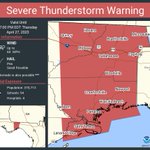
Here’s a look at that severe thunderstorm warning for Leon Co. this includes downtown Tallahassee, FSU and FAMU
FSU Weather retweeted

Tornado warning has been issued for portions of Franklin and Wakulla counties until 9:30 AM EDT. Seek shelter immediately if you are in this area!!

FSU Weather retweeted
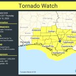
A tornado watch has been issued for parts of Alabama, Florida and Georgia until 5 PM EDT – at Georgia, USA

ALT This graphic displays Tornado Watch watch number 113 plotted on a map. The watch is in effect until 5:00 PM EDT. The watch includes parts of Alabama, Florida and Georgia. The threats associated with this watch are a couple tornadoes possible, isolated hail up to ping pong size possible and scattered gusts up to 70 mph possible. There are 1,224,833 person in the watch along with 398 schools and 41 hospitals.

