

Tracking Hurricanes, Typhoons, & Cyclones worldwide | Real-time updates | Stay safe & informed
Global Service
Joined July 2011
- Tweets35.7K
- Following1.1K
- Followers2.4K
- Likes41.4K







Hurricanes • Typhoons • Cyclones retweeted

This whole season felt like a dream. The series was incredible.
4 years ago today, Astros win their 2nd World Series championship!!
This clip has some happy moments including how people celebrated.
Where were you when we won?
Hurricanes • Typhoons • Cyclones retweeted

We did it @jamestalarico


Congratulations, Governor #GinaHinojosa and Senator #JamesTalarico! May Texas shine brighter, and may our Lone Star State move forward with renewed hope, dignity, and promise.
Texas deserves and has voted for leadership that listens, inspires, and serves with purpose. May their victories mark the beginning of a new era in which every Texan has the opportunity to thrive, where fairness, equality, diversity, inclusion, and compassion guide our path forward, where every voice is valued, every child has the opportunity to succeed, and where the promise of a brighter tomorrow is shared by all, regardless of background or circumstance.
Everything is bigger in #Texas—including the hope for a better tomorrow! Praying for both of our new leaders, God's guidance & light.
Respectfully,
Roshin Rowjee
#NewChapterForTexas #HopeAndProgress


Hurricanes • Typhoons • Cyclones retweeted

History made.

ALT A graphic with photos of James Talarico that reads: "JAMES TALARICO - PROJECTED WINNER - JUNIOR U.S. SENATOR FROM TEXAS."
Hurricanes • Typhoons • Cyclones retweeted

BREAKING: Democrat Gina Hinojosa wins Texas's governor race, NBC News projects. nbcnews.to/4zqAlF8

ALT BREAKING: Democrat Gina Hinojosa wins Texas's governor race, NBC News projects. https://www.nbcnews.com/politics/2026-elections/texas-governor-results
Hurricanes • Typhoons • Cyclones retweeted

Deb Haaland será a primeira governadora indígena na história dos EUA, pelo estado do Novo México

Hurricanes • Typhoons • Cyclones retweeted

Decision Desk HQ projects James Talarico wins the TX US Senate General Election
#DecisionMade: 10:14 PM EST
Follow live results here: votes.decisiondeskhq.com/rac…

Hurricanes • Typhoons • Cyclones retweeted
Fit to wear the crown. 👑
Yordan has been named a 2026 AL MVP finalist!

Hurricanes • Typhoons • Cyclones retweeted
4 years ago today, Cristian Javier, Bryan Abreu, Rafael Montero and Ryan Pressly threw the first combined no-hitter in World Series history.
They beat the Phillies 5-0 to tie the series.
I want to go back….
Hurricanes • Typhoons • Cyclones retweeted

Hey @grok, was the car's driver, William Greer, actually the one who killed JFK?
🌀 Cyclone Arnab / ARNAB UPDATE
— ANDHRA PRADESH, #INDIA 🇮🇳
⚠️ #ExtremelySEVERECyclonicStormArnab THREAT
📍 EXPECTED LANDFALL ZONE: Coastal #AndhraPradesh, potentially between Bapatla and Visakhapatnam, near the Kakinada and Godavari coastal region.
📅 EXPECTED DATE: Wednesday, October 28, 2026.
🕦 PROJECTED TIME: Around 11:30 a.m. Indian Standard Time (IST).
💨 PROJECTED WIND SPEEDS: Sustained winds of 185–210 km/h (115–130 mph), with powerful gusts reaching 230 km/h (143 mph).
🌧️ MAJOR THREATS
Extremely heavy rainfall and life-threatening flooding.
Destructive winds capable of damaging buildings, uprooting trees, and bringing down power lines.
Dangerous storm surge and coastal inundation in low-lying areas.
Hazardous seas along the Andhra Pradesh and southern Odisha coastlines.
🚨 SAFETY ALERT: Coastal residents should prepare for potentially destructive conditions, secure loose outdoor objects, stock essential supplies, and follow evacuation instructions from local authorities. Fishermen should stay out of the sea.
Stay alert. Prepare early. Protect lives.
Respectfully,
Roshin
Hurricane/Typhoon/Cyclone Updates & Information

🌀 #CycloneArnab / #ARNAB UPDATE
— ANDHRA PRADESH, INDIA 🇮🇳
⚠️ EXTREMELY SEVERE #CyclonicStormArnab THREAT
📍 EXPECTED LANDFALL ZONE: Coastal Andhra Pradesh, potentially between Bapatla and Visakhapatnam, near the Kakinada and Godavari coastal region.
📅 EXPECTED DATE: Wednesday, October 28, 2026.
🕦 PROJECTED TIME: Around 11:30 a.m. Indian Standard Time (IST).
💨 PROJECTED WIND SPEEDS: Sustained winds of 185–210 km/h (115–130 mph), with powerful gusts reaching 230 km/h (143 mph).
🌧️ MAJOR THREATS
Extremely heavy rainfall and life-threatening flooding.
Destructive winds capable of damaging buildings, uprooting trees, and bringing down power lines.
Dangerous storm surge and coastal inundation in low-lying areas.
Hazardous seas along the Andhra Pradesh and southern Odisha coastlines.
🚨 SAFETY ALERT: Coastal residents should prepare for potentially destructive conditions, secure loose outdoor objects, stock essential supplies, and follow evacuation instructions from local authorities. Fishermen should stay out of the sea.
Stay alert. Prepare early. Protect lives.
Respectfully,
Roshin
Hurricane/Typhoon/Cyclone Updates & Information

🌀 #CycloneArnab / #ARNAB UPDATE
— ANDHRA PRADESH, INDIA 🇮🇳
⚠️ EXTREMELY SEVERE #CyclonicStormArnab THREAT
📍 EXPECTED LANDFALL ZONE: Coastal Andhra Pradesh, potentially between Bapatla and Visakhapatnam, near the Kakinada and Godavari coastal region.
📅 EXPECTED DATE: Wednesday, October 28, 2026.
🕦 PROJECTED TIME: Around 11:30 a.m. Indian Standard Time (IST).
💨 PROJECTED WIND SPEEDS: Sustained winds of 185–210 km/h (115–130 mph), with powerful gusts reaching 230 km/h (143 mph).
🌧️ MAJOR THREATS
Extremely heavy rainfall and life-threatening flooding.
Destructive winds capable of damaging buildings, uprooting trees, and bringing down power lines.
Dangerous storm surge and coastal inundation in low-lying areas.
Hazardous seas along the Andhra Pradesh and southern Odisha coastlines.
🚨 SAFETY ALERT: Coastal residents should prepare for potentially destructive conditions, secure loose outdoor objects, stock essential supplies, and follow evacuation instructions from local authorities. Fishermen should stay out of the sea.
Stay alert. Prepare early. Protect lives.
Respectfully,
Roshin
Hurricane/Typhoon/Cyclone Updates & Information

* Very Severe #CyclonicStormArnab / #Arnab over Westcentral
Bay of Bengal [Cyclone Warning for Andhra Pradesh and adjoining South Odisha coasts
The very severe #CycloneArnab over Westcentral Bay of Bengal moved
west-northwestwards with a speed of 25 kmph during past 6 hours, and lay centered at 0230 hrs IST of today, the 27th October, 2026 over the same region near latitude 15.9°N and longitude 85.4°E, 300 km southeast of Vishakhapatnam (Andhra Pradesh), 360 km east-southeast of Kakinada (Andhra Pradesh), 380 km south of Gopalpur (Odisha), 460 km east of Machilipatnam (Andhra Pradesh), 530 km east of
Bapatla (Andhra Pradesh) and 920 km west-northwest of Sri Vijaya Puram (Andaman Islands).
Arnab is very likely to continue to move west-northwestwards till evening of 27th October and thereafter, it is very likely to move northwestwards and cross Andhra Pradesh & Yanam coasts between Bapatla and
Visakhapatnam, close to Yanam as a very severe cyclonic storm with the maximum sustained wind speed of 115-125 kmph gusting to 140 kmph by forenoon of 28th October, 2026. The system is under continuous surveillance of the Doppler Weather Radar at Vishakhapatnam.
*** STORM SURHE WARNING ***
Storm surge of 1.0 to 1.5 m height above astronomical tide is very likely to inundate low lying areas of Andhra Pradesh during the time of landfall. The maximum peak surge is expected over near Kakinada and Yanam (Puducherry UT).
Respectfully,
Roshin
Hurricane/Typhoon/Cyclone Updates & Information

* Very Severe #CyclonicStormArnab / #Arnab over Westcentral
Bay of Bengal [Cyclone Warning for Andhra Pradesh and adjoining South Odisha coasts
The very severe #CycloneArnab over Westcentral Bay of Bengal moved
west-northwestwards with a speed of 25 kmph during past 6 hours, and lay centered at 0230 hrs IST of today, the 27th October, 2026 over the same region near latitude 15.9°N and longitude 85.4°E, 300 km southeast of Vishakhapatnam (Andhra Pradesh), 360 km east-southeast of Kakinada (Andhra Pradesh), 380 km south of Gopalpur (Odisha), 460 km east of Machilipatnam (Andhra Pradesh), 530 km east of
Bapatla (Andhra Pradesh) and 920 km west-northwest of Sri Vijaya Puram (Andaman Islands).
Arnab is very likely to continue to move west-northwestwards till evening of 27th October and thereafter, it is very likely to move northwestwards and cross Andhra Pradesh & Yanam coasts between Bapatla and
Visakhapatnam, close to Yanam as a very severe cyclonic storm with the maximum sustained wind speed of 115-125 kmph gusting to 140 kmph by forenoon of 28th October, 2026. The system is under continuous surveillance of the Doppler Weather Radar at Vishakhapatnam.
*** STORM SURHE WARNING ***
Storm surge of 1.0 to 1.5 m height above astronomical tide is very likely to inundate low lying areas of Andhra Pradesh during the time of landfall. The maximum peak surge is expected over near Kakinada and Yanam (Puducherry UT).
Respectfully,
Roshin
Hurricane/Typhoon/Cyclone Updates & Information

* Very Severe #CyclonicStormArnab / #Arnab over Westcentral
Bay of Bengal [Cyclone Warning for Andhra Pradesh and adjoining South Odisha coasts
The very severe #CycloneArnab over Westcentral Bay of Bengal moved
west-northwestwards with a speed of 25 kmph during past 6 hours, and lay centered at 0230 hrs IST of today, the 27th October, 2026 over the same region near latitude 15.9°N and longitude 85.4°E, 300 km southeast of Vishakhapatnam (Andhra Pradesh), 360 km east-southeast of Kakinada (Andhra Pradesh), 380 km south of Gopalpur (Odisha), 460 km east of Machilipatnam (Andhra Pradesh), 530 km east of
Bapatla (Andhra Pradesh) and 920 km west-northwest of Sri Vijaya Puram (Andaman Islands).
Arnab is very likely to continue to move west-northwestwards till evening of 27th October and thereafter, it is very likely to move northwestwards and cross Andhra Pradesh & Yanam coasts between Bapatla and
Visakhapatnam, close to Yanam as a very severe cyclonic storm with the maximum sustained wind speed of 115-125 kmph gusting to 140 kmph by forenoon of 28th October, 2026. The system is under continuous surveillance of the Doppler Weather Radar at Vishakhapatnam.
*** STORM SURHE WARNING ***
Storm surge of 1.0 to 1.5 m height above astronomical tide is very likely to inundate low lying areas of Andhra Pradesh during the time of landfall. The maximum peak surge is expected over near Kakinada and Yanam (Puducherry UT).
Respectfully,
Roshin
Hurricane/Typhoon/Cyclone Updates & Information

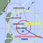
#Champi #SuperTyphoonChampi #Taiwan #TyphoonChampi
0600UTC 22 October 2026
Center Position 20.7N 125.4E
Vector to 6 HR Position
NW 13 km/h
Minimum Pressure 925 hPa
Maximum Wind Speed 51 m/s
Gust 63 m/s
Radius of over 15m/s winds 300km
Radius of over 25m/s winds 150km
Radius of 70% probability circle 30km

#Champi #SuperTyphoonChampi #Taiwan
0600UTC 22 October 2026
Center Position 20.7N 125.4E
Vector to 6 HR Position
NW 13 km/h
Minimum Pressure 925 hPa
Maximum Wind Speed 51 m/s
Gust 63 m/s
Radius of over 15m/s winds 300km
Radius of over 25m/s winds 150km
Radius of 70% probability circle 30km
