
We turn geo-spatial data into decision making info. 1st project - Foresight Crops, provides arable farmers with advanced info on the risk of insect infestation.
Joined December 2016
- Tweets248
- Following124
- Followers40
- Likes295
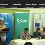






Excellent launch event for the Rum and Sargassum project. The Honourable Minister of Energy provided the keynote. GGIS as a project partner are looking forward to contributing to this innovative project. rumandsargassum.com/
#biofuel #mapping #predictiveanalytics

ALT Dr Legena Henry speaking with a panel of distinguished speakers beside her.
14
The Winners of the Foresight DRM Disaster Mapping Hackathon are:
First place:
Giatri Lalla - "Project Ignite - The Grand Bahama Bushfire 'N Tingz"
Second place:
Parinda, Lisah and Yanika - "EmergencyRoute"
Congratulations!

ALT Screenshot showing images of the hackathon winners and two of the organisers.
Global Geo-Intelligence Solutions is hosting a hackathon.
It focuses on ideas using geo data to facilitate disaster mapping & response.
Win up to 500USD by submitting a working application, a short writeup and a 2 minute video.
Interested?
foresight-drm-mapping.devpos…

86
In a market with a short grain supply, the dry spring weather of 2022 was devastating for European wheat production, according to a new drought monitor that draws on data from ESA’s Soil Moisture and Ocean Salinity (SMOS) Earth observation mission.
1
The Orbiting Carbon Observatory 3, or OCO-3, is a space instrument designed to investigate important questions about the distribution of carbon dioxide on Earth as it relates to growing urban populations and changing patterns of fossil fuel combustion...
1
In 2021 alone, natural disasters struck over 430 times around the globe. In total, these events affected 101.8 million people. Over 10,000 people lost their lives, with economic damage surpassing $250 billion.
The UNOOSA workshop on Space-based Technologies for Disaster Risk...
1
Winners of the Annual Awards for Excellence in Satellite Communications were revealed on the 15th of September during Euroconsult’s World Satellite Business Week (WSBW).
With 200 executive-level speakers, over 1,200 industry leaders, and 480 businesses in attendance, the event
1
On the 10th of September in New Delhi, India, Manoj Ahuja, the Department for Agriculture and Farmer' Welfare secretary, chaired a Technical Advisory Committee meeting on transforming Mahalanobis National Crop Foresight Centre into a center of excellence in geospatial technology
1
Leica Geosystems, part of Hexagon, recently (8th September 2022) announced the introduction of the Leica DMC-4, a highly efficient airborne imaging sensor providing unsurpassed image quality for various applications and complex mapping environments.
1
NV5 Geospatial has announced the debut of the ARIS II Rover, after five years of in-field implementation and testing, its upgraded robotic electric substation monitoring system.
1
Beyond Gravity is part of the first three Artemis missions and delivers important elements for the mission’s Orion spacecraft, the SLS launch vehicles as well as the planned Gateway space station.
For the first time since 1972, humans will land on the moon thanks to Artemis 1.
1
Drought in Southern Parts of the UK
According to the UK Environment Agency, there has been five consecutive months of below-average rainfall across the whole of the UK this year (2022). This along with above average temperatures have had an impact on ground water, lakes...
1
Database vendor MariaDB acquired privately held geospatial data technology vendor CubeWerx in a deal made public last Thursday that will bring the vendor in line with competitors that already offer geospatial capabilities. (1)
1
The summer of 2021 was the hottest on record – with a part of Sicily setting a provisional heat record for Europe at 48.8 degrees Celsius in August. This extreme heatwave ignited wildfires across countries like Greece and Italy...
1
The Nigerian Institution of Surveyors (NIS) has advised the Federal Government to initiate proper geospatial mapping of the nation.
The NIS lamented that the current maps were done in 1965 and are already obsolete.
“With good mapping, we should be able to tackle insecurity. We..
1
Carbon sequestration is the process of capturing and storing atmospheric carbon dioxide.
The United States Geological Survey (USGS) is conducting assessments on two major types of carbon sequestration: geologic and biologic.
1
Foresight Carbon is a satellite-based carbon sequestration monitoring platform offered by us here at GGIS.
#ForesightCarbon #Sequestration #GGIS #Satellites
usgs.gov/faqs/whats-differen…
gg-is.com/projects
GIS helps utility companies with essential components, managing and mapping the location of underground and overhead circuits. It links data, work orders, power outages, vegetation management, and customer information and supports proactive efforts to maintain and monitor the
1
systems of the electrical utility provider.
#GIS #Utility #NetZero #ClimateChange
esri.com/about/newsroom/publ…
mgiss.co.uk/gis-in-the-elect….
As the UK prepares for a winter of extraordinary fuel bills, the Government has recommitted to Net Zero. However, a new Progress Report by the independent Climate Change Committee (CCC) finds major failures in delivery programs toward the achievement of the UK’s climate goals...
1
There are some bright spots of progress, but in most areas the likelihood of under-delivery is high.
#NetZero #UK #ClimateChange #CO2
theccc.org.uk/2022/06/29/cur…