

Weather Enthusiast | NWPAC Climatologist Director & Chief Forecaster @IPTCWC 🐊 Everglades Wildlife Photographer 📸 🏁 NASCAR | 🐘 Roll Tide
Florida, USA
Joined February 2022
- Tweets14K
- Following753
- Followers1.8K
- Likes19.1K





Riley Doxsee retweeted

David Jolly: Trump called me a dog.
Well I don’t care what the old man says!
(Applause)
Riley Doxsee retweeted

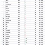
The @SEC accounts for 13 of the 20 toughest schedules in the nation.
No other conference has more than four. 😤
#SECFB x #ItJustMeansMore


Riley Doxsee retweeted

Twenty years ago today, Super Typhoon #Cimaron (2006) struck Luzon. This impressive "140-kt" 🙄 storm had a MODIS TIR eye temp of 25.2°C and WV eye temp of -15.8°C, values commonly found in upper-echelon TCs. Probably the missing ≥155-kt Philippine landfall between Zeb (1998) and Megi (2010).


Riley Doxsee retweeted

One year ago today, Hurricane Melissa intensified into one of the strongest hurricanes ever recorded in the Atlantic/Caribbean with a peak of 190 mph sustained winds (strongest ever recorded & tied with Allen '80) and a pressure of 892 mbars (tied 3rd lowest ever recorded). It's also the strongest storm to ever make landfall since the labor day hurricane back in 1935
It made a catastrophic landfall near Black River which was devastated by storm surge and deal extreme category 5 damage across Western Jamaica. This was by far the strongest storm to hit the country in its history.


Riley Doxsee retweeted

WPAC is king, a collage of 155kts+ TCs this year, a very high density year than usual...


Riley Doxsee retweeted

The STRONGEST STORMS ON EARTH in 2026 by lowest estimated pressure:
🇲🇵 890 mb in Super Typhoon Sinlaku
🇲🇽 892 mb in Hurricane Polo
🇯🇵 895 mb in Super Typhoon Champi
🇲🇵 901 mb in Super Typhoon Bavi
🇯🇵 909 mb in Super Typhoon Dolphin
The Western Pacific has taken the lead in the ACE championship race. It is animated to have a 99.27% chance to win the ACE championship. The record active Eastern Pacific remains closely behind. Both basins look to produce more major storms as we make the push towards November.
🤖 Made with AI

WPAC was ranked 18th on September 20th. That would have been a very average season. This chart also doesn’t count Nolo’s WPAC contribution. Reality is 5th YTD ACE, with only 1997, 2004 and 2015 clearly ahead. We have moved into elite season (top 5) range in the WPAC.

EPAC people when they have locked up the most active season on record and WPAC people when they’re at 350 ACE, and a Gay 1992 is in the works, after just producing 3 majors and 160kt Cat 5s earlier this month and still has all of Nov and Dec to go after IN-FA
I love Champi. It’s one of the favorite storms I’ve ever tracked. But I think some recency bias is involved here. Sinlaku is 165/170, Champi is 160/165. Now it takes much more energy and things going right to get the intensity with Champi’s eye size.


With her new peak intensity of 185 MPH and 895 MBAR, Super Typhoon Champi has officially pulled closer to Super Typhoon Sinlaku’s estimated 185 MPH and 890 MBAR.
Considering their peak satellite presentations, which storm do you now think is the world’s MOST POWERFUL of 2026?


58%Super Typhoon Champi
42%Super Typhoon Sinlaku
689 votes • Final resultsThis looks like something out of a movie, but it’s not, it’s reality. It’s simply something out of the strongest El Niño on record in the western Pacific in October. It’s about equivalent to Tom Brady inside 2 minutes needing a score.

Sunrise on meteorological perfection. It takes immense oceanic heat, pristine atmospheric conditions, and elite top tier execution by the storm to achieve such a specimen. Winds estimated at 160knots (185mph) by the JTWC, could even be higher. This is October in the WPAC.


This is what a textbook successful eyewall replacement cycle looks like. It can be the beginning of the end for most storms, but for #Champi, it went nearly perfect and it has now become a 155kt/899mb buzzsaw. Immense energy required to produce this, with seamless execution.
Riley Doxsee retweeted

#Champi is looking extremely impressive after its latest ERC completed, and is up to 155-knot intensity.
There's still an interesting battle between the dynamical models and AI models for track. Dynamical models (including GFS and Euro) show a slightly stronger ridge to the north and take the storm right into #Taiwan. The AI models (including EC-AIFS and Google DeepMind) show the ridge eroding just enough for the storm to curve east of Taiwan and towards southern #Japan.
I wouldn't bet against AI on a large-scale setup and track given its recent history, but it will be interesting to see.


