

Software Person
Mooresville, NC
Joined January 2009
- Tweets732
- Following78
- Followers546
- Likes338





I've been working mostly in React Native for a while now. I found myself using a lot of the same styling patterns for layout and text so I created a little package for it, native-stylist. It's inspired by but way less powerful than Tailwind, with no deps. github.com/JasonSanford/nati…


This is used in my Ride CLT app, as well as some other projects I've been cooking up. rideclt.app/


every-mile, the bot that is behind @every_mile_brp and @every_mile_at is now open source and open to new trail or path contributions - github.com/JasonSanford/ever…

Jason Sanford retweeted

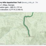
Mile 34 of 2,120: Cleveland, Georgia
Elevation gain: -413 ft (-126 m)
Max elevation: 3,835 ft (1,169 m)
#at #appalachiantrail #thruhiker #backpacking #hiking
The Blue Ridge Parkway roughly parallels the Appalachian Trail and intersects it 9 times, but the AT is much longer at over 2,100 miles. Follow along from Georgia to Maine over at @every_mile_at


Created a twitter bot to tweet every mile of the Blue Ridge Parkway - @every_mile_brp No servers, just some GitHub actions reaching out to the @Mapbox API. 👋🏻 @BlueRidgeNPS ... Appalachian Trail next?

Created a twitter bot to tweet every mile of the Blue Ridge Parkway - @every_mile_brp No servers, just some GitHub actions reaching out to the @Mapbox API. 👋🏻 @BlueRidgeNPS ... Appalachian Trail next?
Health Care & Corporate Responsibility by @tonyquartararo link.medium.com/1rdh4QS5iU There are many reasons I love working at @spatialnetworks and this is certainly one of them.
Verifying myself: I am jcsanford on Keybase.io. YWcKAMw6dQuunQrc51-NICw7uFEDQN-tuCXM / keybase.io/jcsanford/sigs/YW…
Jason Sanford retweeted

Excited to release some of our most requested @fulcrumapp features today! We've been working on this for a while. fulcrumapp.com/blog/introduc…
I stole lots of ideas from @bobws' excellent MapTab and created weather-tab github.com/JasonSanford/weat…

They are automatically created when using the mobile apps or the web app to create or update records.
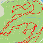
Do GPS devices go bad? A garmin that used to stick consistently to the trail now does this with every ride.

I wrote a little about this process to help Fulcrum customers who only have address data. fulcrumapp.com/blog/geocodin…
csvgeocode is a great tool for geocoding CSV files using Mapzen Search. github.com/veltman/csvgeocod…
Jason Sanford retweeted

@zacmcc stuffs #proj4js into @fulcrumapp calculation fields for some on-the-fly projection fun in the field: fulcrumapp.com/blog/custom-p…
Jason Sanford retweeted

improving map rendering speed and quality => blog.cartodb.com/smaller-fas…
shapefile-ags exports shapefiles from ArcGIS Server endpoints - github.com/JasonSanford/shap…