




NEW: Severe Thunderstorm Warning for far western Chariton and Saline counties until 9:15 PM for 60 mph wind gusts. #midmowx

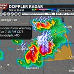
A Severe Thunderstorm Warning is in effect until 7:15PM for southern Macon and northern Randolph counties for 1" hail and 60 mph winds. It's drifting east/NE at about 15 mph #midmowx


We have a wet Friday morning commute ahead! How long rain and clouds stick around will determine the intensity and coverage of a potential round 2 by late afternoon. Futuretrack timeline at 5 & 6 on @ABC17News #midmowx


Heads up Truman Lake and Sedalia: a line of damaging winds is approaching from the west. This could also affect #LakeoftheOzarks after 2:00 PM #midmowx
So proud of my amazing niece! 👏🏻

Tears of heartfelt joy filled the Capitol Rotunda as students read their winning essays from our Letters to the Lieutenant Governor America 250 contest. You could see parents, teachers, veterans, and guests wiping away tears as students shared why they love America and are proud to be Americans. Their words about freedom, faith, family, opportunity, and gratitude were a powerful reminder that patriotism is alive and well in the next generation.
If these young Missourians are America’s future, our next 250 years are in very good hands. 🇺🇸


Spooky skies this afternoon at @FLYFROMCOU! Heavy rain/flooding is the main concern through tomorrow morning as rounds of storms move through #MidMO tonight. I'll have the Weather Alert Day timeline at 5 & 6 on @ABC17News #midmowx

NEW: Severe Thunderstorm Watch (pink) and Tornado Watch (yellow) in effect for Mid-Missouri until 10:00 PM. Tornadoes, 70+ mph winds, and large hail will be possible in severe storms by late this afternoon. #midmowx

A Severe Thunderstorm Warning is in effect until 1:15 PM for northern Pulaski, central Phelps, and southern Maries counties for 60 mph winds and 1” hail. Head indoors if you’re inside the yellow polygon! #midmowx

Jessica Hafner retweeted

A tornado watch has been issued for parts of Iowa and Missouri until 11 PM CDT

ALT This graphic displays Tornado Watch watch number 210 plotted on a map. The watch is in effect until 11:00 PM CDT. The watch includes parts of Iowa and Missouri. The threats associated with this watch are a few tornadoes likely, scattered hail up to tennis ball size likely and scattered gusts up to 70 mph likely. There are 330,490 people in the watch along with 299 schools and 27 hospitals.
SUNDAY AT 10 on KMIZ: I'm working on a two-part series ahead of the 15 year anniversary of the EF-5 tornado that hit Joplin on May 22, 2011. I'll take you inside the new Mercy Joplin to show you how the hospital has led the way in storm resilience in hospital settings nationwide.


RADAR 6:30 PM (4/17/26): Tornado warned storm could approach Warsaw around 7PM #midmowx

NEW: Severe Thunderstorm Warning for Moniteau Co. until 12:00 AM for 60 mph winds. A brief spin up tornado is possible. #midmowx

NEW: Severe Thunderstorm Warning for northern Benton Co. until 11:15 PM for 60-70 mph winds and small hail. #midmowx

NEW: Severe Thunderstorm Warning until 10:30 for northern Pettis and western Saline counties for 60 mph winds #midmowx

A Flood Watch is in effect for much of Mid-MO tonight as 1-3" of rain could fall over some of the same locations that saw 1-2" of rain in the last 24 hours. Low water crossings will be dangerous into the morning! #midmowx

SNOW SQUALL: Snow Squall Warnings are in effect until 5:45PM for Pettis, Saline, Chariton, Howard, and Cooper counties as winds have increased to 35 mph, blowing snow around and dropping visibility under 1/4 mile. Try to stay home if you can! #midmowx
NEW: Severe Thunderstorm Warning for far eastern Pulaski and southern Phelps Co. for 60 mph winds #midmowx

A Severe Thunderstorm Warning continues for central Miller and western Maries counties until 2:45PM for the potential of up to 60 mph winds. #midmowx
