

Mapping Archaeological Heritage in South Asia - hosted at the University of Cambridge, supported by @ArcadiaFund.
Joined March 2021
- Tweets1.3K
- Following74
- Followers753
- Likes1.3K


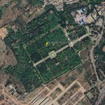



Did you know? On the Survey of India Map of 1915, you can spot a hidden architectural treasure—Jal Mahal in Pinjore, Haryana! This majestic palace, nestled amidst lush gardens, is clearly marked on the map and also visible on satellite imagery today!

1
6
231

#HeritageHighlights
We’re thrilled to debut our Fun Topography Sandbox! Using real sand + AR, you can shape mountains, valleys, and see contours & water flow in real-time! Perfect for teaching geology and maps during outreach—and doubles as a relaxation spot in the office!
#AR
107
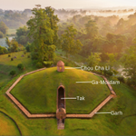
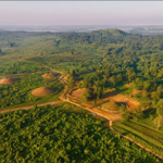
In today’s #HeritageHighlight we continue our exploration of the Moidams, the royal burial mounds of the Ahom Dynasty in Assam, which recently attained UNESCO World Heritage status. #Moidams #AhomDynasty #AssamHeritage #UNESCOWorldHeritage #Charaideo #TaiAhomCulture #AssamHistory

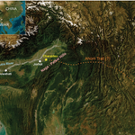
The Ahoms, a Tai-Ahom group, ruled Assam from the 13th to the 19th century CE. This unique necropolis, featuring around ninety Moidams, is in Charaideo— the dynasty's first capital (see the map). #AncientArchitecture #RoyalBurialMounds #CulturalHeritage #MeDamMePhi #TarpanRituals

1
1
29
For today’s #MapsMonday we explore Assam's rich geography, using maps that reveal its diverse landscapes of flowing rivers and rolling hills. The Survey of India map of 1925 below highlights the region of Naga Hills and Sibsagar Districts.

1
2
164

We were at the @RGS_IBG conference with @induprasad to talk about the Indians who mapped archaeology.
Follow the link for our storymap;
storymaps.arcgis.com/stories…
#esri #storymap #archaeology #southasia


#MapMonday today is a #storymap about the Indian Surveyor Lal Singh and his physical and professional journeys in surveying and archaeology.
storymaps.arcgis.com/stories…
#archaeohistories #map #SouthAsia

We are proud to announce MAHSA Phase 2🎉🎉
A big thank you to the Arcadia Fund and all the researchers, archaeologists, librarians and everyone else who has supported us.
#Celebrations #mahsaproject #archaeology #southasia
For todays #MapMonday check out this interesting map of Bahawalpur, Pakistan.
This map shows the ancient river source of the Hakra river and possible water channels of the Sutlej river system in the area.

Happy 78th Independence Day to India! Today, the nation celebrates its journey as the world's largest democracy, reflecting on the sacrifices made for its freedom. Here’s to unity, resilience, and the spirit of India! #IndependenceDay2024 #Tiranga #PrideOfIndia

89
Happy 78th Independence Day, Pakistan! Today, we honour the vision of Muhammad Ali Jinnah and the diverse cultural tapestry that makes this nation unique. Here's to unity, progress, and pride! #IndependenceDay2024 #Pakistan #UnityInDiversity #NationalFlag #History

109
In today's #mapmonday we are looking at 3 graveyards. These graveyards were identified on a 1909 historic Survey of India map. Swipe left to see where the ever-changing river is now!

1
10
160

For today's #HeritageHighlights post, we look at the recently passed festival of Guru Purmina (Jule 21)! This festival has Vedic and Buddhist roots, celebrated in India, Nepal, and Bhutan. It focuses on celebrating scholastic work.
For today's #MapMonday we have a map of #Taxila created by John Marshall in the early 20th C. Like the Survey of #India maps they capture an epic landscape of high hills and rivers. But unlike the SoI #maps, you can more clearly see the #archaeological sites.

This ancient city, known as 'Taxila', was a city on the #SilkRoad that flourished for years and shows traces of occupation from the Neolithic period. In the 5th B.C. to the 2nd century A.D. It became a seat of #Buddhist learning and pilgrimage. Read more -
stories.durham.ac.uk/TaxilaI…


Style of the fort has been marked by the pluralistic #culture and different regimes that have controlled historic Lahore, with Sikh, Hindu, and Muslim #architectural styles.

65
In today’s #Mapsmonday dive into the heart of Lahore’s ancient urban core, the Walled City, also known as "Anderoon Shehr." Spanning 256 hectares, this historic gem dates back to the Mughal era, with Emperor Akbar's reign leaving a lasting architectural mark. #WalledCityLahore

The city’s layout embodies a unique three-step space philosophy, featuring public zones, central courtyards, and private areas. These courtyards were central to social life, providing light, ventilation, and a space for gatherings. #HistoricLahore #MughalArchitecture #map

1
45
For todays #mapmonday we have this beautiful early 20th century map from Lahore, Pakistan. In this weeks heritage highlight, we will look at the history behind this map! #Southasia #southasianheritage #Archaeology #History #Heritage #maps #pakistan #lahore #cartography

Eid Mubarak from the @mahsa_project and team!
We hope everyone has a blessed Eid wherever you are and that you can spread the joy and kindness to those who have need of it in troubled times.
#eidmubarak #eidaladha #mubarak

#HeritageHighlights go to Lahore! On a rare day off, we ventured into the old Walled City of Lahore.
The street markets are as busy and lively as many remember in their childhood.
#lahore #heritage #travel
@ArcadiaFund


#HeritageHighlights in Harappa with two of the MAHSA team. After seeing the site in books and maps for years it was a true highlight to see it for ourselves!
This Indus Valley site gave way to the term 'Harappan' and is now a @UNESCO site.

To look at them now, you can understand how early #archaeologists believed the bricks to be modern! In fact, a number were taken away to make railroad tracks at the turn of the century.
But after years of #excavation, they revealed wells, granaries and industrial zones...
