

Official X account for the National Weather Service Boise. Details: https://xitter.gq/t.co/kwtncnlnle
- Tweets15.6K
- Following522
- Followers28K
- Likes6K


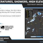



ALT Valley rain and high mountain snow will return Friday, increasing in coverage late Saturday into Sunday. Snow levels will hover between 5500 to 6500 feet, with heavy accumulations on mountain summits.


ALT This graphic displays a special weather statement plotted on a map. The statement is in effect until 5:15 PM MDT. The statement includes Fairfield ID and Featherville ID. STRONG THUNDERSTORMS WILL IMPACT EAST CENTRAL ELMORE and CAMAS AND NORTHEASTERN GOODING COUNTIES THROUGH 515 PM MDT. The threats associated with this storm are wind gusts up to 55 MPH and pea sized hail. Seek shelter in a sturdy structure until the storm passes.

ALT This graphic displays a special weather statement plotted on a map. The statement is in effect until 4:30 PM MDT. The statement includes Jerome ID, Gooding ID and Wendell ID. STRONG THUNDERSTORMS WILL IMPACT NORTHWESTERN JEROME, EAST CENTRAL ELMORE and SOUTHERN CAMAS AND GOODING COUNTIES THROUGH 430 PM MDT. The threats associated with this storm are wind gusts up to 55 MPH and half inch sized hail. Seek shelter in a sturdy structure until the storm passes.

ALT This graphic displays a special weather statement plotted on a map. The statement is in effect until 4:00 PM MDT. The statement includes Mountain Home ID, Gooding ID and Wendell ID. The threats associated with this storm are wind gusts up to 50 MPH and half inch sized hail. Seek shelter in a sturdy structure until the storm passes.

ALT This graphic displays a special weather statement plotted on a map. The statement is in effect until 3:15 PM MDT. The statement includes Mountain Home ID, Mountain Home Air Force Base ID and Glenns Ferry ID. The threats associated with this storm are wind gusts up to 50 MPH and pea sized hail. Seek shelter in a sturdy structure until the storm passes.