

Weather discussions and information for the Upper Midwest including Minnesota & Wisconsin along with Rochester, Minneapolis & St. Paul.
Minneapolis, MN
Joined May 2009
- Tweets19.5K
- Following362
- Followers10.1K
- Likes6.4K




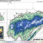


Here is where the RAIN has fallen so far this afternoon & evening. Notice the widespread heavy amounts north of the Twin Cities while more scattered activity was found from the Twin Cities on south & east.

Here is the recorded 5pm LIVE severe weather briefing from Facebook. Enjoy! facebook.com/share/v/1DJgNqM…
I will be going LIVE on Facebook at 5pm today to discuss the SEVERE weather scenario that is unfolding over portions of MN/WI where a TORNADO Watch is currently in effect. I hope you can join me.

Keep an eye to the sky over the next 12 hours. After today, our weather pattern turns QUIET until early next week. Meanwhile, the WARMTH shows no signs of giving way. Here is your extended outlook.

Here is the latest SEVERE weather video briefing for MN, WI & IA. As crazy as it sounds, we have the potential for severe T'Storms later this afternoon & into the evening. Enjoy! facebook.com/share/v/1CAnBKL…
I've got my eye on tomorrow PM as the unseasonably WARM conditions produce T'Storms. Meanwhile, the current active weather pattern will turn quiet later this week & this will set us up for a nice Halloween. Here is your extended outlook.

The threat for SEVERE weather is increasing for tomorrow PM as storms rapidly develop after 2pm. A strong low level jet will surge north into an east moving cool front to create a potentially volatile environment, especially for late OCT standards. Here is the set-up.

Can you believe this? Trick or treaters will NOT need a jacket this weekend as the WARMTH continues. Again, I don't see any true Arctic air until mid-NOV at the earliest. Meanwhile, I won't be surprised if T'Storms get a little feisty tomorrow PM. Here is your extended outlook.

Another much needed & healthy RAIN fell over much of the Upper Midwest & Northern Plains over the last 24 hours. Meanwhile, since the ground is not frozen yet, this moisture is soaking in. Check it out!

Still absolutely NO Arctic air is in sight. In turn, any snow or freezing temperatures talk will have to hold off thru at least mid-NOV. On the other hand, the threat for RAIN & T'Storms is there, especially between now & Thursday. Here is your extended outlook.

A cool front will push thru MN cabin country today bringing much cooler air along with some showers & T'Storms. By Sunday, temperatures will be more normal for late October. Here is your 'UP NORTH' outlook.

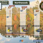
The crazy October Warmth will continue in northwest WISCO as near record temperatures are likely thru today. Eventually, a cool front will move thru overnight bringing cooler temperatures for Sunday along with some showers. Here is your 'NORTHWOODS' outlook.

There are still NO hints of winter anywhere over the lower 48 of the U.S. Here is the latest 00z ECMWF potential snow map thru the first week of November. Notice that most of the accumulation looks to stay north of the border in Canada.

There are still NO hints of anywhere over the lower 48 of the U.S. Here is the latest 00z ECMWF potential snow map thru the first week of November. Notice that most of the accumulation looks to stay north of the border in Canada.

Our incredible October WARMTH will eventually come to an end by early next week. Along with the COOLER weather will come the potential for a widespread, soaking RAIN. Here is your extended outlook.

I'm finally starting to see some hints of true Fall as we head into next week & towards Halloween. However, still no big storms are sight. Hopefully we receive some much needed moisture over the weekend. Here is your extended outlook.

Simply put, there is NO Arctic air or big storms in sight thru at least this weekend. This will likely go down as the warmest October ever along with below normal rainfall. Here is your extended outlook.

We are well on our way to the WARMEST October ever on record. The string of WARM days will extend thru the week & weekend. Meanwhile, DRY conditions will be the rule until later Friday. Here is your extended outlook.

Look at this incredible late OCT forecast. Our next opportunity for a freeze doesn't arrive until early NOV as temps will be above normal & skies should be dry thru this weekend & much of next week. Here is your extended outlook.

