

Sharing the Planetary Geomorphology Image of the Month blog from the @IAGAIG Planetary Geomorphology working group. Curated by @fegbutcher
- Tweets143
- Following60
- Followers652
- Likes28



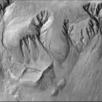



ALT Crater rim gullies in Terra Sirenum, northwest of Newton Crater, HiRISE image ESP_022676_1410.


ALT An example of a typical river valley system on Earth with a dendritic drainage pattern in Yemen [Source: Landsat]. (Top Right) Fluvial landform annotated in blue by Burr et al., (2013) in radar imagery of Titan, showing a rectangular drainage pattern [Source: NASA Cassini]. (Bottom Left) Radar image of linear dunes in the Namib Desert on Earth. The linear dunes, similar in size to those on Titan, are 1-2 km apart. (Bottom Right) Linear dunes in Titan’s sand sea imaged by Synthetic Aperture Radar [Source: NASA Cassini].


ALT Barchan dune covered by dark-toned ripples with spacings between crests of ~3 m. These bedforms are migrating over brighter-toned transverse aeolian ridges (TARs). HiRISE image ESP_027864_2295_COLOR (credit: NASA/JPL/University of Arizona).

ALT The largest crater in the western portion of the northern region of Anshar Sulcus (Ganymede). In the, the upper panels show the current position of the crater as seen from the 2865_r and 2878_r Galileo SSI images (left) and topographic data (right) , and in the lower panels the images have been manipulated to show the reconstruction of the possible original position of the surface. (Credit: Ianiri et al., 2023).