

Mapmaker, mountaineer and GIS Coordinator of The Icelandic Met Office
Iceland
Joined August 2013
- Tweets898
- Following762
- Followers1.7K
- Likes2.8K






Pinned Tweet
Earthquakes in Iceland in 2022. This years catalogue holds about 35 thousand quakes that have been checked and validated by The Icelandic Met Office. Happy new year 🎆 🎇 #gischat #dataviz #earthquakes #iceland
Made with #qgis using data from @Vedurstofan
Day six of the sixth eruption near #Svartsengi and the town of #Grindavik This eruption is the largest one yet. Here is a 4-day series of #Sentinel5p satellite data from the #TROPOMI instrument showing the mean amount of SO₂ in a vertical column of atmosphere (Dobson units).


Here is @Vedurstofan / @dmidk short-range forecast running for +66 hrs. at 2.5 km grid size from noon today.
Also available here: spakort.vedur.is/kort/spakor…

Greenland melting conditions today and tomorrow, especially high across the northeastern ice sheet @ArcticBasecamp


Finally found a good reason to use @felt
Made a map for a kid’s football tournament where my 7yr old twins participated. Shared with all parents.
Where are all the different pitches? Where is the accommodation? Where is the campsite?
Just look at the map 👇🏼⚽️🗺️ – at Iceland


Super nice to have weather radar data available in @Windycom directly from @Vedurstofan in their app. Perfect for timing my morning commute 🚲
Will start this morning at the home desk.
See rainfall arriving in reply 👇🏼 – at Iceland
You can just about make out our tracks in the snow on this #sentinel1 image from the 4th of June, especially the very straight tack East of Grímsvötn.
Image shows backscatter values (sigma0) for the VV channel mapped to a white/red color ramp
@CopernicusEU @jorfi_iceland


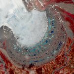
The false color near infrared band combination for #sentinel2 is very useful when looking at proglacial lakes. The lighter colors tell us that the lake is being actively filled with glacial meltwater. In some situations, this might lead to floods if there is no active outlet. – at Iceland


#ImageOfTheDay
Múlajökull is a glacial tongue that is part of the Hofsjökull #glacier system in #Iceland 🇮🇸
Its ice margin 🧊 is renowned for its unique geological formations alternating with a series of small lakes 🟦🟩
⬇️#Copernicus #Sentinel2 🇪🇺🛰️ image of 31 May

Replacing a seismic station on Kárasker, a nunatak visible from Jökulsárlón (visible in the background) ☀️

Just about ready for tomorrow trip. Joining the #Vatnajökull glacier spring survey campaign. A weeklong collaborative effort @uni_iceland, @jorfi_iceland and @Vedurstofan collecting data and maintaining equipment.

Somewhere on Vatnajökull ☀️

Just about ready for tomorrow trip. Joining the #Vatnajökull glacier spring survey campaign. A weeklong collaborative effort @uni_iceland, @jorfi_iceland and @Vedurstofan collecting data and maintaining equipment.
Just about ready for tomorrow trip. Joining the #Vatnajökull glacier spring survey campaign. A weeklong collaborative effort @uni_iceland, @jorfi_iceland and @Vedurstofan collecting data and maintaining equipment.
The crater lake in #Askja slowly loosing ice as the days get slightly warmer. Still lots of snow it seems. Image acquired by Landsat 8 on May 17 @USGSLandsat

You should definitely check out @newgeographer2 fat list of #QGIS expressions. Including the 2.5D contour geometry generator expression
This is Snæfellsjökull #Iceland 🌋
Yes, you can control the geometry expression and the decoration title with the same variable.

Added to my big list of qgis expressions:
github.com/geographyclub/qgi…

Contours at 5 m interval base on #ArcticDEM from @polargeospatial with improvements from @Landmaelingar Get it here: atlas.lmi.is/mapview/?applic…
Katla, one of our ice-filled volcanic calderas is keeping everyone on their toes @Vedurstofan
Seismic swarm started at 09:41 UTC with 3 earthquakes of M >4 in the middle of the caldera. Aviation colored moved to yellow as a result. Image acquired by #sentinel2 on April 23rd. – at Iceland

This one and the MODIS image captured at same time have sparked a lot of interest, discussion and joy among cloud enthusiasts at The Icelandic Met Office @Vedurstofan – at Iceland

Random Series | #Iceland as magical as always
Amazing cloudy shapes on its eastern side while Jökulsá á Brú pumps brightful & turbid waters into the Norwegian Sea; 2023-04-20. Open & zoom to see the details.
@CopernicusEU #Sentinel2 🛰️ #EO
Full Size: https://xitter.gq/t.co/wc501F0l8h 🧐

Snæfellsjökull is not only one of Iceland’s most picturesque central volcanoes, but it’s also a great peak to visit during spring either on foot or on skis. Highly recommend it. Awesome views in all directions (photos from a week ago).
icelandicvolcanos.is//?volca… – at Iceland


As a multi hazard monitoring agency, having #MDAL available as part of @qgis is incredibly powerful for us at @Vedurstofan. We can drag and drop our GRIBs straight from the source and visualize the latest weather forecast.
Thanks @lutraconsulting 🙏♥️