State_of_Mind (@StateofMind_02) header
State_of_Mind (@StateofMind_02) profile picture

I tell of numbers, stars, and land, And creatures walking nature’s sand. Support the journey, learn, and find

Jupiter
Joined March 2024
Photo by State_of_Mind (@StateofMind_02)Photo by State_of_Mind (@StateofMind_02)Photo by State_of_Mind (@StateofMind_02)Photo by State_of_Mind (@StateofMind_02)Photo by State_of_Mind (@StateofMind_02)Photo by State_of_Mind (@StateofMind_02)Photo by State_of_Mind (@StateofMind_02)Photo by State_of_Mind (@StateofMind_02)Photo by State_of_Mind (@StateofMind_02)Photo by State_of_Mind (@StateofMind_02)
This is the Dendera Zodiac, an ancient Egyptian carved star map. It’s a circular stone relief showing the sky constellations, and planets as the Egyptians understood them. It was found in the Temple of Hathor at Dendera and dates to the Greco-Roman period (around 50–100 BCE).
1
3
114
🌐 Internet Freedom Rankings 🇮🇸 Iceland → 94/100 🇪🇪 Estonia → 91/100 🇨🇱 Chile → 87/100 🇨🇷 Costa Rica → 86/100 🇨🇦 Canada → 85/100 🇳🇱 Netherlands → 84/100 🇹🇼 Taiwan → 79/100 🇯🇵 Japan → 78/100 🇫🇷 France → 76/100 🇬🇧 United Kingdom → 76/100 🇦🇺 Australia → 75/100 ..... ....
1
97
🇩🇪 Germany → 74/100 🇮🇹 Italy → 74/100 🇺🇸 United States → 73/100 🇿🇦 South Africa → 73/100 🇦🇲 Armenia → 72/100 🇦🇷 Argentina → 71/100 🇬🇪 Georgia → 70/100 🇭🇺 Hungary → 69/100 🇷🇸 Serbia → 67/100 🇧🇷 Brazil → 65/100 🇰🇷 South Korea → 65/100 🇨🇴 Colombia → 64/100
1
1
49
15 consecutive years → Global internet freedom declined through 2025. Source: Freedom House, Freedom on the Net 2025.
24
I use BSNL services.
Dear Prime Minister Ambani, Please accept my humble apologies for not realizing that you are the real boss of India. Naturally, you would prefer to maintain your monopolistic exploitation of the great people of India, but would you nonetheless consider allowing Starlink to compete? There are many areas of India, as there are in all countries, with no Internet access, which denies children the opportunity for education and for small businesses the opportunity to sell their goods to a global market. Starlink would change their lives for the better. Thank you 🙏
1
1
115
Basically, an entire capital city squeezed onto a tiny island. The island is only about 9 km², yet it is packed with high-rises, roads, homes, and tens of thousands of people. Almost no empty land. Just city surrounded by ocean.
Malé, the capital and most populous city of the 🇲🇻 Maldives.
4
137
Utrecht’s historic canal system is older than Amsterdam’s canal ring by several centuries.
Catharijnesingel canal in Utrecht, Netherlands 🇳🇱 In the 1970s, city planners filled in this 900-year-old moat to build a 12-lane sunken motorway. Decades later, a 2002 citizen referendum sparked a massive restoration project to undo the damage. Fully reopened in 2020, the waterway now flows again, letting boats circle the historic center for the first time in a half-century.
1
5
172
🇳🇱 Friesland is the only Dutch province where Frisian and Dutch are both official languages.
Flag of Friesland, a province of the Netherlands.
4
155
There are 2 ways to define seasons 🌍 ☀️ Astronomical → Based on Earth’s position around the Sun. 🌡️ Meteorological → Based on temperature and 3-month periods. Same 4 seasons, different ways of measuring them.
5
64
The supernova of 1054 was so bright that it remained visible in broad daylight for about 23 days. Chinese astronomers recorded it as a “guest star,” and it remained visible to the naked eye at night for nearly two years.
The supernova responsible for the Crab Nebula was observed in 1054 and cataloged as a “guest star” by Chinese astronomers. Over the past two decades, we’ve been able to map the changes in the cloud of debris left behind by this explosion. #MondayMotivation
3
105
Why does the Jing River look different from nearby rivers? The Jing River in China carries huge amounts of sediment from the Loess Plateau, especially during the rainy season. When its muddy water meets the clearer Wei River, the two can flow side by side before mixing, creating a striking natural contrast known as "Jing Wei Distinction" (泾渭分明).
4
92
30 Map Projections - Why Do We Keep Using These ? 1. Mercator → Navigation 2. Web Mercator → Online maps 3. Gall Peters → True area 4. Robinson → Balanced world view 5. Winkel Tripel → Less overall distortion 6. Mollweide → Equal area mapping 7. Equal Earth → Equal area and natural shape 8. Sinusoidal → Global data maps 9. Eckert IV → Equal area world map 10. Eckert VI → Equal area mapping 11. Goode Homolosine → Reduces land distortion 12. Albers Equal Area → Large regions 13. Lambert Conformal Conic → Regional maps 14. Equidistant Conic → Distance focused maps 15. Polyconic → Topographic mapping 16. Azimuthal Equidistant → Distance from center 17. Lambert Azimuthal → True area 18. Stereographic → Preserves angles 19. Orthographic → Globe like appearance 20. Gnomonic → Great circle routes 21. Plate Carree → Simple world grid 22. Equirectangular → Global datasets 23. Transverse Mercator → Narrow zones 24. UTM → 60 global zones 25. Miller Cylindrical → Reduced polar distortion 26. Van der Grinten → Circular world map 27. Hammer → Equal area world map 28. Aitoff → Balanced world map 29. Kavrayskiy VII → Reduced distortion 30. Two Point Equidistant → Two point distances
BREAKING: President Trump teases a U.S. expansion map that would include Canada, Greenland, Mexico, Cuba, parts of Central America, & the Caribbean.
2
201
Why do winds move around Earth? 🌍💨 The Sun heats Earth unevenly. Warm air rises near the Equator, while cooler air sinks elsewhere. This creates giant wind patterns: 💨 Trade Winds 💨 Westerlies 💨 Polar Winds Together, they help move heat around our planet. 🌎
2
83
How did humans spread across Asia and the Pacific? This map shows estimated ancient human migrations, based on mitochondrial DNA. 🔴 170–130k years ago 🟠 70–60k years ago 🟡 35–25k years ago 🟢 15–12k years ago 🔵 9–7k years ago The arrows show how different groups moved, split and spread into new regions over thousands of years. Our ancestors didn't reach every place at once, it was a long journey across generations. Source: mitochondrial DNA population genetics
1
70
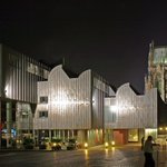
Did you know? This is Cologne, Germany, where the huge Cologne Cathedral stands right beside a modern museum and a major railway station. The interesting part? Hundreds of years of history are packed into one view: ⛪ Gothic cathedral 🎨 Modern Museum Ludwig 🚆 Cologne Central Station It’s a great example of how old and new architecture can exist side by side in the same city. History doesn't always replace the new sometimes it grows alongside it.
4
73
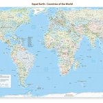
The UN did not redraw borders. It asked the world to stop treating a 1569 sailor’s chart as the default picture of how big continents are.On 4 Sept 2026 the UN General Assembly passed “Correct the Map.” Vote: 164 yes · 1 no (United States) · 6 abstain. It encourages maps that show true land size, especially the Equal Earth projection, in schools, media, and institutions. No country gained land. The picture of size is what they want to fix.
2
1
6
1,975
11/12 So what should we remember when we look at a world map? Before comparing countries by how big they look, let's ask: “Which projection am I looking at?” That's a small question with a big impact. For example: 🧭 Navigation? → Mercator can be useful. 📏 Comparing area? → Equal Earth or another equal-area projection is better. 🌎 Understanding the actual shape of Earth? → Look at a globe. The best map depends on what we're trying to understand.
1
46
12/12 And here's the lesson we can take away. 🌍 There isn't one flat map that can show everything perfectly. Every projection makes some choices. So the next time we look at a world map, let's remember: A map is a tool — not the Earth itself. Mercator helps us understand direction and navigation. Equal Earth helps us understand relative size. And a globe reminds us what our planet actually looks like. Once we understand the map, we understand the world a little better. 🌎
1
41