

#Maps that will help you make sense of the world. https://xitter.cf/t.co/hYkqtedPIU https://xitter.cf/t.co/xdV6v8YFRo
Earth
Joined March 2015
- Tweets8.8K
- Following4.7K
- Followers16.2K
- Likes339








Vivid Maps retweeted

Y'all liked the US map, so I did Europe. Same approach: every @nytimes international article since 2000 (n≈199,000) turned into a map of which topics are covered disproportionately (where coverage was sufficient to calculate). Results by country below, alphabetical 👇


Vivid Maps retweeted

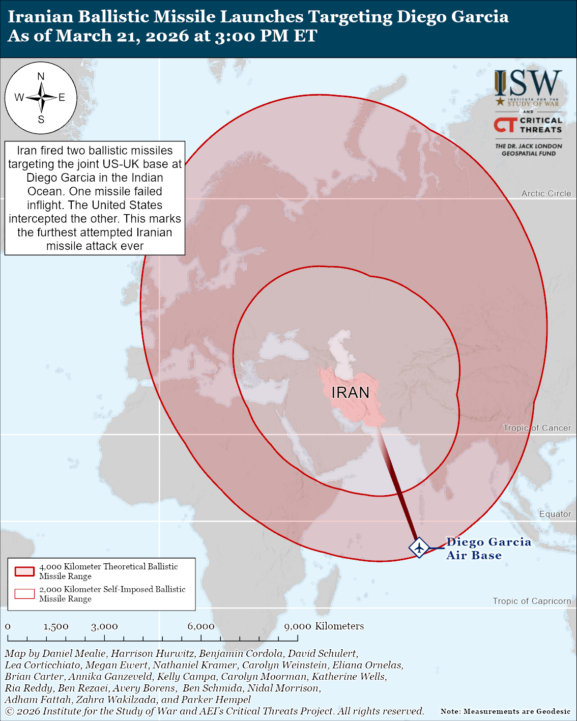
NEW: Iran launched two ballistic missiles targeting the US-UK base at Diego Garcia in the Indian Ocean on March 21, marking the furthest ever attempted Iranian missile strike. The attack demonstrated that Iranian missiles can reach beyond the 2,000-kilometer limit that the regime has long claimed to have self-imposed. One missile failed inflight, and the United States intercepted the other.
Other Key Takeaways:
The Islamic Revolutionary Guards Corps (IRGC) has reportedly expanded its influence over regime decision-making amid a growing power vacuum caused by leadership losses and Supreme Leader Mojtaba Khamenei’s apparent inability to exercise full authority. Some of the officials who have likely expanded their influence are among the most aggressive and repressive elements within the IRGC.
The United States Treasury Department issued a short-term waiver on March 20, permitting the sale of Iranian oil already in transit. The waiver does not allow for new purchases of oil.
The combined force continued to degrade Iran’s missile production capabilities. The IDF struck at least five missile production sites in Tehran.


Vivid Maps retweeted

Elevation Finder: Höhenangabe gefällig? / Would you like the altitude? geoobserver.de/2026/02/19/el… via @VividMaps #gistribe #gischat #fossgis #foss4g #OSGeo #spatial #geospatial #gis #geo #geoObserver pls RT


Vivid Maps retweeted

US President Donald Trump’s long-running fixation on acquiring Greenland has escalated into a transatlantic imbroglio.
We look at why Trump wants the island aje.news/j01fdh

Vivid Maps retweeted

🚨🇨🇴 BREAKING: Colombia’s President Gustavo Petro announces that he wants to rebuild the state of Gran Colombia after being inspired by yesterday’s tweet by @hispano_studies.
Gustavo Petro wrote the following message tonight, posting the same map from the original tweet:
“This is the Gran Colombia, it was Bolívar's idea and I propose by constituent vote of the population that we rebuild it as a confederation of autonomous Nations.
We would have common policies in the matters that the people propose.
Undoubtedly the commercial policy toward industrialization and being what it is geographically a center of the world and of Latin America.
A center of clean energies, of knowledge, of high-technology infrastructures for mobility and communication.
On those there would be a Gran Colombian parliament, a court of justice and a government council, like in the European Union or in the federal USA.
A potential for tourism and for world connectivity”


Está es la Gran Colombia, era la idea de Bolívar y propongo por voto constituyente de la población, que la reconstruyamos como una confederación de Naciones autónomas.
Tendríamos unas políticas comunes en las materias que proponga el pueblo. Indudablemente la política comercial hacia la industrialiación y ser lo que es geográficamente un centro del mundo y de Latinoamérica. Un centro de energías limpias, del saber, de infraestructuras de alta tenología de movilidad y comunición. Sobre esas habría habría un parlamento grancolombiano, un tribunal de justicia y consejo de gobierno, como en la Unión Europea o en los EEUU federales.
Una potencial del turismo y de la conectividad del mundo.


Vivid Maps retweeted
Land border with the biggest time gap
mapsontheweb.zoom-maps.com/p…


Vivid Maps retweeted
Tree canopy height of Paris, France. Have given up on #30DayMapChallenge.
#rayshader adventures, an #rstats tale

ALT A 3D path-traced visualisation of Paris' tree canopy heights