

Alpena & Northeast Michigan weather. Get your full 7-day forecast on WBKB News at 6 p.m. & 11 p.m. For news updates follow @WBKB11.
Joined December 2019
- Tweets1.1K
- Following26
- Followers24
- Likes3


WBKB Weather retweeted

Severe Thunderstorm Warning including Alpena MI, Hubbard Lake MI, Ossineke MI until 1:15 AM EDT – at Michigan, USA

WBKB Weather retweeted
Severe Thunderstorm Warning including Skidway Lake MI, East Tawas MI, Tawas City MI until 1:15 AM EDT – at Michigan, USA

Scattered thunderstorms will move through Northeast Michigan Saturday morning-afternoon, highs will reach about 80 degrees. The next chance of thunderstorms will roll in Sunday afternoon-evening.
Northeast Michigan's weather: wbkb11.com/thunderstorm-chan…
#Michigan #weather
Friday will begin dry, then a risk of thunderstorms will develop late-day. Highs will reach about 80 degrees. On/off chances of showers and thunderstorms continue through the weekend.
Get the latest on Northeast Michigan's weather: wbkb11.com/risk-of-thunderst…
#Michigan #weather
MDOT webcams in Lachine and near Glennie have caught a couple isolated showers moving through Northeast Michigan.
Saturday, we'll have a risk of thunderstorms in the morning and afternoon. Highs will reach the middle 70s. There could be a couple spotty shower Sunday, but overall it's looking drier.
Get the latest on Northeast Michigan's weather: wbkb11.com/risk-of-thunderst…
#Michigan #weather
A bright and cool Friday, the day will start with temperatures in the lower 50s, afternoon highs will reach the lower 70s.
Get the latest on Northeast Michigan's weather: wbkb11.com/bright-and-cool-f…
Showers and a risk of thunderstorms will move through tonight. A few spotty showers are possible early Thursday. Colder temperatures will follow late-week.
Get the latest on Northeast Michigan's weather: wbkb11.com/risk-of-thunderst…
The first chance of rain and thunderstorms will move through Northeast Michigan later tonight to early Tuesday. There could still be a few spotty showers Tuesday afternoon. Highs will reach the upper 70s.
Northeast Michigan's weather: wbkb11.com/on-off-chances-of…
#Michigan #weather
We'll have a risk of severe thunderstorms Saturday morning and afternoon. Gusty to damaging winds will be the main threat. Highs will reach the lower to middle 80s and it'll feel very sticky.
Northeast Michigan's weather: wbkb11.com/risk-of-severe-th…
#Michigan #weather #storm #humid

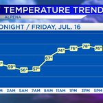
Temperature forecast - next 18 hours:
Cooling to the lower 60s & upper 50s overnight. Early-morning lows will be near 58°. Morning temperatures will rise to the 60s & lower 70s. Midday temperatures will reach the upper 70s to almost 80°. Afternoon highs will get up to about 82°.

Humidity will go up and also the chance of rain and thunderstorms will by early Saturday.
Get the latest on Northeast Michigan's weather: wbkb11.com/getting-sticky-ov…
#Michigan #weather #humid
WBKB Weather retweeted

Severe thunderstorm warnings will have 3 designations.
Baseline severe: Winds at least 58 mph and/or hail at least quarter size.
“Considerable”: Winds at least 70 mph and/or hail at least golf ball size.
“Destructive”: Winds at least 80 mph and/or hail at least baseball size.

Starting July 28, Severe Thunderstorms deemed “destructive” will activate a Wireless Emergency Alert (WEA) on smartphones. Criteria for a destructive threat is at least 2.75 inch diameter hail and/or 80 mph thunderstorm winds.
Read more: weather.gov/news/072221-svr-…
