Chris Shaffer (@WCCOShaffer) header
Chris Shaffer (@WCCOShaffer) profile picture

WCCO-TV Chief Meteorologist

Minneapolis, MN
Joined September 2009
Photo by Chris Shaffer (@WCCOShaffer)Photo by Chris Shaffer (@WCCOShaffer)Photo by Chris Shaffer (@WCCOShaffer)Photo by Chris Shaffer (@WCCOShaffer)Photo by Chris Shaffer (@WCCOShaffer)Photo by Chris Shaffer (@WCCOShaffer)Photo by Chris Shaffer (@WCCOShaffer)Photo by Chris Shaffer (@WCCOShaffer)Photo by Chris Shaffer (@WCCOShaffer)Photo by Chris Shaffer (@WCCOShaffer)
Chris Shaffer retweeted
⚠️ TORNADO WARNING for Burnett, Pine county until 10/28 5:45PM. TAKE COVER NOW in a basement, interior room or closet on the lowest level of your home. More: [Link in bio] #mnwx #wiwx
7
4
2
3,317
Chris Shaffer retweeted
⚠️ TORNADO WARNING for Dakota, Goodhue, Pierce county until 10/28 5:30PM. TAKE COVER NOW in a basement, interior room or closet on the lowest level of your home. More: [Link in bio] #mnwx #wiwx
6
10
9,327
Chris Shaffer retweeted
⚠️ SEVERE T-STORM WARNING for Dakota, Rice, Scott county until 10/28 5:00PM. 1"+ hail and/or 60+ mph winds are possible. More: [Link in bio] #mnwx #wiwx
4
3
2,850
Chris Shaffer retweeted
⚠️ SEVERE T-STORM WARNING for Kanabec, Mille Lacs county until 10/28 5:00PM. 1"+ hail and/or 60+ mph winds are possible. More: [Link in bio] #mnwx #wiwx
1
3
3
2,769
Chris Shaffer retweeted
⚠️ SEVERE T-STORM WARNING for Mille Lacs, Benton, Isanti, Kanabec county until 10/28 5:00PM. 1"+ hail and/or 60+ mph winds are possible. More: [Link in bio] #mnwx #wiwx
2
2
2,887
Chris Shaffer retweeted
⚠️ SEVERE T-STORM WARNING for Kanabec county until 10/28 4:45PM. 1"+ hail and/or 60+ mph winds are possible. More: [Link in bio] #mnwx #wiwx
2
2,281
Chris Shaffer retweeted
⚠️ SEVERE T-STORM WARNING for Pine county until 10/28 5:00PM. 1"+ hail and/or 60+ mph winds are possible. More: [Link in bio] #mnwx #wiwx
2
1
2,332
Chris Shaffer retweeted
⚠️ SEVERE T-STORM WARNING for Rice, Le Sueur county until 10/28 4:30PM. 1"+ hail and/or 60+ mph winds are possible. More: [Link in bio] #mnwx #wiwx
2
1,810
Unusual...but not unheard of...Tornado Watch until 9pm. The latest in the season we've had a Tornado Watch was December 15th of 2021.
3
1
8
831
Chris Shaffer retweeted
⚠️ SEVERE T-STORM WARNING for Meeker, Wright, Stearns county until 10/28 2:45PM. 1"+ hail and/or 60+ mph winds are possible. More: [Link in bio] #mnwx #wiwx
3
4
2,498
Chris Shaffer retweeted
⚠️ SEVERE T-STORM WARNING for Meeker, Kandiyohi county until 10/28 2:15PM. 1"+ hail and/or 60+ mph winds are possible. More: [Link in bio] #mnwx #wiwx
2
1
2,551
Chris Shaffer retweeted
⚠️ SEVERE T-STORM WARNING for Kandiyohi, Chippewa county until 10/28 1:45PM. 1"+ hail and/or 60+ mph winds are possible. More: [Link in bio] #mnwx #wiwx
3
3
2,482
Chris Shaffer retweeted
⚠️ SEVERE T-STORM WARNING for Yellow Medicine, Chippewa, Renville county until 10/28 1:15PM. 1"+ hail and/or 60+ mph winds are possible. More: [Link in bio] #mnwx #wiwx
3
2
2,582
The Storm Prediction Center has the metro included in a slight risk (2 on a scale of 5) for severe storms including large hail, damaging winds and a 5% chance of tornadoes sometime between 3-8pm. Our Next Weather team will keep you informed.
1
1
3
710
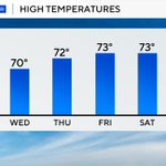
Far out man...we've warmed to the 70s!
4
16
782
Volleyball…no. Soccer…no. It’s a mushroom! Are these normal, or were we walking over a nuclear site this morning?
3
3
719
It's a Diana Ross forecast...No Wind, No Rain...Nor Winter's Cold. Ain't no mountain high enough to block our glorious weather this week.
3
8
1,022
We golfed all morning Bob Seger style…Against The Wind! It was cold, but it was a blast. Do you remember a tough weather round of yours?
1
12
711
Expect widespread frost Saturday morning with many towns falling to 32 or colder. Cover 'em if you want to keep 'em.
1
1
1
453
Over half an inch of rain so far in the metro with more on the way. We will trade the rain for a big wind and freezing conditions in the next few days.
1
4
617