Hi there! We are @YourHistoryMaps. We are sharing all kinds of maps relating to our beautiful world. Like, retweet and follow us!

Joined June 2018
Crossing the Waal river in #Nijmegen. Part of operation Market Garden, #theNetherlands, 1944. #WW2
4
5
Large detailed old map of #Vienna city 1547.
Beginnings of the Papal States 756–814.
8
22
Map showing the spread of Islam and the Abbasid empire.
1
8
16
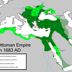
The Ottoman Empire at its greatest extent in Europe, under Sultan Mehmed IV in late 17th century.
1891 distribution of English and Gaelic in Scotland.
5
14
County of Zeeland, Jacob van Deventer, around 1580.
10
20
The most valuable brand in each country in 2018.
6
10
What if the European Union had 28 states with equal populations.
7
3
27
Liberated territory in #Yugoslavia and grouping of forces of the People's Liberation Army of Yugoslavia and of the invaders towards the end of September 1944. #WW2
1
1
Beautiful illustrated map of Constantinople (nowadays #Istanbul) by Simon Pinargenti,1573.
Paris during the French Revolution, 1790s.
16
31
Satisfaction with Life Index.
1
3
1
5
The commercial network of the Phoenicians.
9
20
Expansion of the Ottoman Empire.
Map of Central-Europe, 18 april 1945. A few weeks before the end of #WW2.
3
4
1
21
German defenses at the Atlanic Coast, better known as 'Atlantikwall'. #WW2
1
3