

Real-time tweets of incidents taking place in San Bernardino Mountain communities. Sponsored by the leader in real-time information https://xitter.gq/t.co/LdszSkK7hG.
Big Bear Lake, CA
Joined December 2010
- Tweets23.9K
- Following47
- Followers4.1K
- Likes126




Bigbearscanner.com retweeted

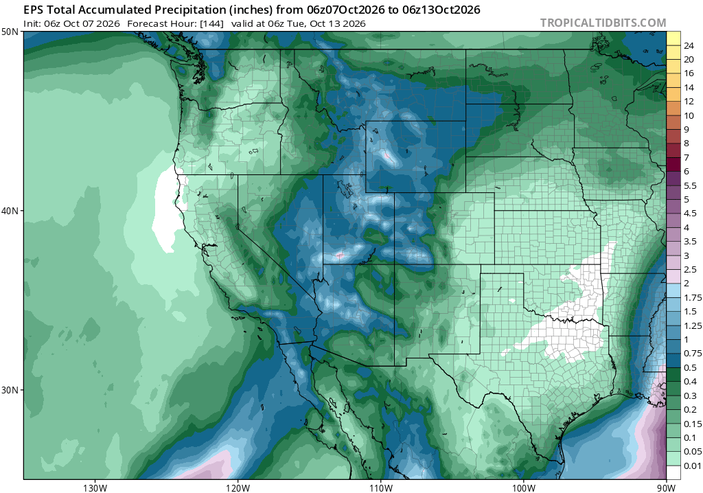
The forecast remains on track for some cool and unsettled weather to arrive this weekend, though ensembles still disagree somewhat on where the heaviest rain will fall. Regardless, most areas in Southern California should pick up at least a quarter of an inch, with higher totals of around a half to one inch possible from Orange County southward.
Localized amounts of 1-2" are also possible on southwest-facing coastal slopes from the San Bernardino Mtns south. This low-pressure system will tap into an atmospheric river and likely direct the deepest moisture to our south over Northern Baja and east into Arizona.
We'll remain dry through tomorrow with some high clouds around, breezy afternoons, and near-normal temperatures. Expect clouds and winds to increase on Saturday morning, with showers developing during the afternoon. The brunt of this storm will arrive Saturday night into Sunday.
This system has originated from a lower latitude; as a result, warmer air will keep the snow level at or above 9,000 feet but could lower a bit Sunday night as precipitation tapers off and cooler air arrives.
A weak offshore flow will develop Monday into Tuesday behind the departing system, with dry weather currently forecast throughout next week. There is another weak system that will brush our area to the north on Wednesday, but precipitation chances look minimal at best.
Worthy of noting, a lot of locations across SoCal are already running 100-200% of average for rainfall since the start of our new rainy season, and we are only in month 1.


Bigbearscanner.com retweeted
Rainfall amounts around the area so far have been about as expected, with higher amounts north, lesser amounts down south.
With the colder & more unstable environment around this afternoon, scattered showers and thunderstorms will continue, with the snow level generally above 8,000 feet, where we have seen some of the white stuff higher up. Travelers, beware as you may encounter snow over some of the higher mtn passes, and carry those chains!
Any thunderstorms that develop could be strong to isolated severe and capable of producing heavy rain, gusty winds, lightning, and hail. In the mountains, that may even translate to some graupel or a few flakes mixing in!
Activity will wind down tonight as low pressure exits the region with a mild Santa Ana developing through the weekend. This will bring cool & breezy conditions in most locations with below-normal temperatures.
Fair and warmer weather returns throughout most of next week, with forecast models advertising more unsettled weather to finish off the month, but it's too far out for any details.
Enjoy the weather out there today, and everybody stay safe!


Bigbearscanner.com retweeted
Cool and unsettled weather continues across Southern California today as a cold low-pressure system moves in from the northwest. This will bring scattered light showers throughout the day, with the snow level currently at about 9,000 feet. Additional rainfall amounts of around a tenth of an inch are possible, with localized amounts up to a quarter inch possible near any thunderstorms this afternoon.
As temperatures cool this evening, the snow level may lower to around 7,000 feet, which may bring our first dusting of the season up at resort level, possibly even a few flurries overnight around Big Bear. San Gorgonio Peak has already received a couple of inches above 10,000 feet.
This trough will slide east tomorrow, with high pressure building in through the end of the week for drier conditions and gradually warmer temperatures. We may also experience a mild offshore flow later in the week, but strong Santa Anas are not expected at this time.
Rainfall totals over the past 72 hrs. were highly variable, impressive in some areas, not so much in others. The heaviest rain fell from Orange County east and south, with lesser amounts north and west towards LA County.
Longer-range forecasts look pretty dry across SoCal for the remainder of the month, with some models advertising wet weather returning around the end of the month. But that's too far out for any level of confidence. Enjoy the cooler weather at last and have a great week!


Bigbearscanner.com retweeted
FLOOD WATCH IN EFFECT FROM SATURDAY EVENING THROUGH SUNDAY
EVENING...
* WHAT...Flooding caused by excessive rainfall is possible.
* WHERE...A portion of Southwest California, including the following areas: the Apple and Lucerne Valleys, Coachella Valley, Riverside County Mountains, San Bernardino County Mountains, San Diego County
Coastal Areas, San Diego County Deserts, San Diego County Mountains, San Diego County Valleys and San Gorgonio Pass near
Banning.
* WHEN...From Saturday evening through Sunday evening.
* IMPACTS...Excessive runoff may result in flooding of rivers, creeks, streams, and other low-lying and flood-prone locations.
* ADDITIONAL DETAILS...
- Tropical Storm Rachel will bring periods of moderate to heavy rain to all of San Diego County, Riverside County mountains and deserts, and San Bernardino County mountains and deserts. Maximum hourly rainfall rates of 0.50 to 0.60 inches per hour are
possible for San Diego Coast and Valleys. Maximum hourly rainfall rates of 0.50 to 0.70 inches per hour are possible across area deserts, and 0.70 to 1 inch per hour rates are possible across area mountains. Heaviest rainfall is most likely late Saturday night through Sunday afternoon.
- weather.gov/safety/flood

Bigbearscanner.com retweeted
For the second time in recent years, parts of Southern California are under a Tropical Storm watch Saturday night through Sunday, including San Diego County and south across Northern Baja. The last time was with Hilary in 2023. Of course, SoCal has been hit with several tropical systems dating back to the 1800s, but this is the 2nd instance of an actual NHC product issued for our area.
Rachel continues to rapidly weaken today and looks relatively unimpressive on satellite. However, due to warmer waters off of Baja, some restrengthening is possible before it makes landfall over Northern Baja.
This will draw deep tropical moisture into the region over the weekend, with widespread rainfall likely by Saturday night into Sunday, driving pw's to an impressive 500% of normal, record levels. A few isolated thunderstorms are possible, but the severe threat will remain on the eastern side of this system, near the Colorado River and extending east into Arizona.
Total rainfall amounts of 0.50"-1.00" are still likely across much of Southern California, with 1-2" in our mountains. Localized amounts over 2 inches are possible in a few locations, mainly southern mountains over San Diego County and along lower coastal slopes with good upslope. This could produce areas of flooding, especially below recent burn scars; be prepared!
Damaging winds are less of a threat, but gusts up to 50 mph are possible across the higher elevations and through passes. Showers look to taper off Sunday night before round 2 arrives on Monday. This will be a colder system with scattered showers and isolated thunderstorms possible in all areas on Monday.
While the snow level will remain above 10,000 feet during Rachel, they could drop off to around 7,000 feet by Monday night, with our first snowfall of the season possible up at resort level.
Conditions look to clear out on Tuesday, with fair and warmer weather returning later next week. For all the latest updates, always check out Bensweather!


Bigbearscanner.com retweeted

🌧️With Tropical Storm Rachel approaching, @NOAA is forecasting rainfall, strong wind gusts, and possible snowfall across RIV and SB counties beginning Sunday, October 11. Please remain alert while traveling and prepare for wet/windy roadway conditions. Stay safe and plan ahead!


Bigbearscanner.com retweeted
Much hoopla is brewing with Hurricane Rachel over the Eastern Pacific, and for good reason, as its remnants are increasingly likely to impact Southern California. The system is expected to arrive as a remnant low rather than an organized tropical storm, posing less of a wind threat and more of a rain threat, providing a good start to our rainy season.
High pressure remains the dominant weather feature this week, supporting above-normal temperatures for a few more days. These warm conditions will persist through Friday with temperatures 5-10 degrees above average across most locations. However, the strengthening onshore flow is beginning to reestablish the marine layer along the coast for some relief.
As high pressure weakens on Friday, a closed low-pressure system is forecast to dig southward off the California coast, drawing moisture northeastward from weakening Hurricane Rachel. Rachel, currently a minimal hurricane, is expected to weaken into a tropical storm later today and will likely be sheared apart by this approaching low, allowing much of its moisture to reach Southern California.
Showers could develop as early as Saturday night. Then widespread rainfall with isolated thunderstorms appear likely on Sunday as the remnants move through the region, with the heaviest amounts expected south and east of Los Angeles. Due to the warmer tropical air mass, snow levels will remain above 9,000 feet.
The colder low offshore is then forecast to move inland through our area on Monday, bringing a significant cool-down along with scattered showers and thunderstorms. Temperatures may fall 5–10 degrees below normal, providing a sharp contrast to the recent warmth. Snow levels could even lower to around 7,000 feet Monday night, potentially bringing the season’s first light snowfall in some higher mountain communities.
Rainfall amounts of 0.25 to 0.50 inches are likely across most of Southern California, with higher totals of 0.50 to 1.00 inch possible across the lower coastal slopes and mountains. Though it should be noted, this is the mean forecast, as models vary from around a tenth of an inch up to 2 inches, and this may be adjusted as we get closer.
Low pressure should exit the area by Tuesday, with fair weather and gradually warming weather returning next week. Current forecast models advertise dry conditions through the middle of the month, although another period of unsettled weather is possible after about the 17th, potentially associated with additional tropical system(s).
For all the latest updates, always check out Bensweather online!


Bigbearscanner.com retweeted

VICTORVILLE: #SBCoFD is assisting @BLMca on a VEGETATION FIRE in the area of Bell Mountain Rd. & Powerline Rd. Approx 40-50 acres with a moderate rate of spread. Additional resources requested and en-route. #PowerlineFire

Bigbearscanner.com retweeted
Looking at a pretty nice day all around today with slightly below-normal temperatures and dry conditions, for now. Hurricane Marie continues chugging along to the north-northwest out to sea and is beginning to weaken as it reaches the cooler waters of the Pacific. This system will likely become a tropical storm later today or tomorrow.
As it begins to unwind, low pressure off the West Coast will draw tropical moisture northeastward in our direction, with a fairly widespread rain event expected tomorrow.
Most areas will experience gusty west winds 10-15 mph today as the onshore flow strengthens, with gusts to 25 in the mountains and through passes with comfortable, fall-like weather out there.
Clouds will increase tonight with showers developing, then expect scattered showers and thunderstorms throughout the day on Sunday. Overcast skies may somewhat limit thunderstorm activity, with the greatest risk from Orange County north and over our Mountains & Deserts, but everyone has a shot at some wet weather!
Total rainfall amounts of around a tenth to a quarter inch can be expected in most locations, with localized amounts around a half inch or more possible, especially over the mountains and near any thunderstorms.
Moisture will move east of the area on Labor Day before high pressure builds back towards the West. This ridge is forecast to set up shop near the Four Corners region throughout much of next week, putting SoCal in a late-season monsoon pattern with afternoon showers and thunderstorms continuing over our mountains and deserts.


Bigbearscanner.com retweeted

⚠️ WEATHER ALERT: FLASH FLOOD & MUDSLIDE RISK
Heavy rainfall is expected this weekend. Rainfall may create dangerous conditions throughout San Bernardino County, especially in and around the Line Fire and Bridge Fire burn scar areas. Burn scars are more susceptible to flash flooding, mudslides and debris flows.
Stay safe:
• Avoid burn scar areas, washes, canyons and low-lying areas during heavy rain.
• Never drive or walk through flooded roadways.
• Be alert for rapidly rising water, mud, rocks or debris.
• Follow all road closures and evacuation warnings or orders.
• Keep your phone charged and monitor official sources for weather and emergency updates.
Conditions can change quickly. Stay alert and be prepared to take action if needed. For more storm and flood information visit
burnareainfo.sbcounty.gov

ALT Mudslide and flash flood warning flyer for San Bernardino county specifically in the Line Fire and Bridge Fire burn scar areas
Bigbearscanner.com retweeted
Finally enjoying some cooler, dare I say almost fall-like weather out there, with temperatures forecast to drop below average for the first time in a while as meteorological fall begins tomorrow. Autumn officially arrives on Tuesday, Sept. 22nd at 5:05 PM.
Unfortunately, we’ll still have the humidity to contend with, as water temps in the Pacific remain well into the 70s, 5+ degrees above average in most areas. Daytime highs in the mountains will drop into the lower 70s for much of this week, with overnight lows dipping back into the 40s, cooling further by the weekend. Most of Southern California will enjoy a nice cool-down, with temperatures across the board 5+ degrees below average this week.
Conditions will remain dry throughout the week with gusty west winds 15-30 mph through mountain passes, elevating fire weather concerns. A big question mark remains for the weekend. Lots of hype over the yet-to-develop tropical cyclone 500 miles south of Cabo San Lucas. This system remains very unorganized at this time, with a 90% probability of developing into a named storm over the next 24-48 hours.
Where it goes after that is still TBD, but contrary to popular belief, there’s little to no chance of a landfalling hurricane across Southern California. There’s only a 2% chance of it even reaching our area as a tropical storm.
Much the same was the case back in 1997 with the powerful Cat 5 Hurricane Linda. We were experiencing almost identical conditions: one of the strongest and most destructive climate events in recorded history and abnormally high sst’s. The initial forecast track brought it onshore over San Diego as a Tropical Storm. This system ended up undercutting the trough off the West Coast (like now), effectively steering it westward out to sea. The majority of the ensemble forecast models currently do the same with Invest 95E (EP95).
This still needs to be monitored for any alterations in track and possible influx of tropical moisture that could result in showers and thunderstorms over our Labor Day weekend, especially across local mountains and deserts. Stay weather-aware and always choose your sources wisely! For the latest info, visit bensweather.com
#cawx #socalwx #camonsoon #bigbearwx #monsoon #monsoon2026 #hurricaneseason #eastpac #hurricanehype


Bigbearscanner.com retweeted
Thunderstorms over Western Arizona last night sent another decent outflow in our direction for added moisture and instability today. With sufficient daytime heating, we're seeing scattered showers and thunderstorms firing up around the region this afternoon, with one active cell a couple miles south of Big Bear Lake along Hwy 38, another off the 40 near Ludlow. Additional storms are developing over Big Bear City, Big Bear Lake and across the Riverside/San Diego County Mtns.
A southeast flow around a high-pressure system near the Four Corners will draw additional monsoonal moisture into the region throughout the week ahead, with scattered afternoon & evening thunderstorms likely each day. Most of this activity will be confined to the mountains & deserts, but a few storms could drift west over our valleys.
Coverage and intensity of convection will vary from day to day, with some storms capable of producing locally heavy rain, gusty winds, dangerous lightning, and small hail. Always head indoors when thunder roars. If you can hear thunder, you are close enough to be struck.
Activity will continue towards the end of the week before low pressure off the West Coast produces a drier southwest flow aloft, kicking monsoon moisture east of us. We'll also have to watch this low for potential impacts across our region next weekend.
For the latest local weather info and live webcams, always check out: bensweather.com
#monsoon2026 #cawx #bigbearwx

Bigbearscanner.com retweeted

As Strike Team 9351C begins its journey to Washington, we want to take a moment to recognize the dedicated firefighters who have answered the call once again.
Comprised of engines from CAL FIRE San Bernardino–Inyo–Mono Unit (BDU) and CAL FIRE Riverside Unit (RRU), and led by Strike Team Leader Chief Manny Barriga, these firefighters are deploying to provide initial attack support on emerging wildfires over the next 18 days.
While many see the engines rolling down the highway, what often goes unseen are the families standing behind them. To the spouses, children, parents, and loved ones who once again say goodbye without hesitation—thank you. Your sacrifice, strength, and unwavering support make this mission possible, and we are grateful for each of you.
To our firefighters: thank you for your commitment to protecting communities, no matter where the mission takes you. Your professionalism, courage, and dedication embody the very best of CAL FIRE.
From all of us at CAL FIRE BDU and CAL FIRE RRU, we wish Strike Team ST9351C safe travels, a successful assignment, and a safe return home. Know that you are appreciated, supported, and in our thoughts every mile of the way.
Stay safe. Take care of one another. We’ll be looking forward to welcoming you home.
#CALFIRE #CALFIREBDU #CALFIRERRU #StrikeTeam #WildlandFirefighters #Washington #InitialAttack #FireServiceFamily #SafeTravels – at Perris, CA

Bigbearscanner.com retweeted
Space X launch tonight at 8:08 PM from Vandenberg. Just after sunset and visible across most of SoCal and the Southwest!

🚨 🪼 STARLINK 17-52 🪼 🚨
Tonight’s @Starlink launch from @SLDelta30 will produce a jellyfish for a large area of the south western US and North Western Mexico. Head on over to maxq.app/launches/falcon-9-b… for all the details along with our video and interactive map!

Bigbearscanner.com retweeted

Helicopter 531 is preparing for night flying operations on the #GreenFire in Mill Creek Canyon. The fire is 33 acres and being managed under unified command by @CALFIREBDU, @SBCOUNTYFIRE, and @SanBernardinoNF .
Bigbearscanner.com retweeted
Evacuation Warning - Green Fire ⚠️
July 27, 2026
The areas of Mountain Home Village and MTH01 are now under an Evacuation Warning.
Residents who may need additional time to evacuate, as well as those with pets or livestock, should leave now.
To view the current evacuation status map, visit:
sbcounty.maps.arcgis.com/app…
Please continue to monitor our social media pages for the latest updates.


Bigbearscanner.com retweeted
From the San Bernardino Mountains to the Boundary Waters of Minnesota, the Del Rosa Hotshots are answering the call. This highly specialized crew from @SanBernardinoNF is responding to the #SiouxFire northwest of Ely, Minnesota.


Bigbearscanner.com retweeted
So far, we're looking at a relatively uneventful day with a few storms firing off down over the San Diego County and Riverside County mountains. Unfortunately, a slightly drier south-southwest flow has infiltrated the area, nudging deeper moisture off to our east. This has brought precipitable water levels down, and as a result, lower cape values and less instability. We're also looking at a cap around 350mb or 25,000 feet that's preventing a lot of vertical growth.
Of course, the abundance of mid/upper-level moisture over the past few days didn't do us any favors, snuffing out a lot of our surface heating for storms to develop.
We may still overcome these variables this afternoon with a few isolated showers and thunderstorms firing off. I expect a very similar setup for tomorrow, allowing temperatures to also increase by 5-10 degrees for most areas. So we'll have more heat and humidity to contend with.
Our broad ridge extends from the Four Corners region east over the Midwest, holding SoCal on the western periphery of the monsoon flow through Thursday. That will change on Friday as high pressure expands further west, putting us in a more favorable east-southeast flow. In addition to increasing moisture again, we'll have to watch for another easterly wave tracking westward into the area.
This should help produce more widespread convection over the weekend, with some storms capable of heavy rain, gusty winds, frequent lightning, and small hail.
The monsoon flow will stay with us through early next week, before a drier southwest flow temporarily pushes monsoon moisture to our east.
Before planning your outdoor activities and for all the latest, be sure to check bensweather.com
#cawx #camonsoon #monsoon2026 #bigbearwx


Bigbearscanner.com retweeted
A collapsed thunderstorm complex turned MCV is traversing Southern California this afternoon, generating a few light sprinkles and showers. This area of disturbed weather may throw down a bolt or two, so be on guard today.
As skies begin to clear, we should destabilize the atmosphere enough for at least some isolated convection. However, the latest soundings show meager instability and cape values today. So we're not expecting a huge outbreak of storms with the best chance over our mountains, where we have a lifting mechanism via terrain.
PW's are fairly high, at 1.44", so any storms that do develop could produce some heavy rain, gusty winds, and small hail. Severe storms are not expected today.
We are looking at a little increase in moisture and better instability for tomorrow, provided that too much cloud cover doesn't snuff out our surface heating.
The monsoon flow looks to remain very active throughout the week and into next weekend. Possibly enhanced by a weak upper-level low and/or additional moisture from the south later in the week. We'll also be dealing with some pretty extreme heat, driving up the heat index!
So be prepared if you have interests outdoors, as storms could fire up just about anywhere at any time, but primarily focused over our mountains and deserts.
#camonsoon #monsoon2026 #cawx #bigbearweather


Bigbearscanner.com retweeted
Monsoon season is about to shift into high gear across the Desert Southwest as high pressure sets up shop near the Four Corners this weekend, then meanders around throughout much of next week.
This will draw deeper tropical moisture into the region for an increasing chance of afternoon convection. Dewpoints have reached the 50s and 60s for the past several days across much of Arizona, a sign the monsoon has officially begun.
Moisture will slowly expand westward, with a few afternoon clouds expected through Saturday over our mountains. The first push of moisture should arrive on Sunday with isolated storms possible over the mountains and southern/eastern deserts. A few sprinkles are possible west of the mountains in our coastal/valley areas.
An inverted trough, aka easterly wave, will be drawn westward out of Arizona Monday into Tuesday with more numerous showers and thunderstorms likely over much of SoCal. With the strongest storms focused over our mountains and deserts, where a few could turn severe.
Longer range is a bit hazier on the specifics, but generally expect the monsoon flow to remain very active throughout next week, possibly enhanced by another wave or additional moisture injected from a tropical system off Mexico.
If you have outdoor activities planned over the next 10 days, keep a watchful eye on the sky and head indoors when thunder roars. If you can hear thunder, you are close enough to be struck. Thunderstorms are always capable of producing locally heavy rain, hail, frequent lightning, and strong, damaging winds! For the latest, always head over to bensweather.com
#camonsoon #monsoon2026 #bigbearwx #cawx


