

Founder, Basemap Consulting. Fast LiDAR, surveys and cultural resources for energy and development. Drone mapping and inspection. Christian, husband, dad of 3.
Forsyth, GA
Joined November 2008
- Tweets43.7K
- Following3.2K
- Followers12.6K
- Likes77.1K


Pinned Tweet
6 American forts in LiDAR.
The first one is a Civil War star fort in New Mexico. Hard to see in the photo. Easy to see in the bare earth.
Public USGS data. Which fort should we do next?
#LiDAR #History #Forts #Surveying
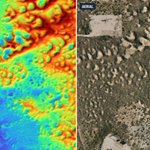
Every little dune under the mesquite.
Left: drone LiDAR bare earth. Right: the aerial.
#LiDAR #Permian #OilAndGas #Surveying

This is what we're looking for.
A ring ditch 300 feet across in Acre, Brazil. Real LiDAR, trees and grass taken off.
One survey in 2024 mapped 432 earthworks here. Only 36 were known.
Help fund the next scan: terraincognitaresearch.org/d… (pick "Gojira")
#LiDAR #Amazon #Archaeology
New 9 minute feature on Dr. Daniel Pierce and Chris Bodine of Terra Incognita Research Institute. Geoglyphs in the Brazilian Amazon, from LiDAR to boots on the ground. These are the archaeologists behind Project GOJIRA. youtube.com/watch?v=UVDHKPFp…

Want to help fund the scan? terraincognitaresearch.org/d… (pick "Gojira" on the form)
72
When your hook snags, you go in after it.
No spare hooks. So you wade into black water full of piranha and dig for it by hand.
Dr. Daniel Pierce, lead archaeologist on Project GOJIRA.
Help fund the next trip: terraincognitaresearch.org/d… (pick "Gojira")
#Amazon #Archaeology
2
351
There's a square under this forest.
About 400 feet across, in Acre, Brazil. A LiDAR flight made to measure the trees found it.
This is what Project GOJIRA is going after next year.
Help fund the scan: terraincognitaresearch.org/d…
#LiDAR #Amazon #Archaeology
Pads and cuts on an active site.
Track the grading without walking the whole thing.
#LiDAR #Earthwork #Surveying
9
573
1925. He walked into the Amazon and never came out.
Percy Fawcett made seven trips looking for a lost city he called Z.
Dr. Daniel Pierce, lead archaeologist on Project GOJIRA.
Help fund the next trip: terraincognitaresearch.org/d… (pick "Gojira")
#Amazon #Archaeology


Daniel Windham retweeted
All 12 forts are in the full video: youtu.be/1LW2rTfM0js

All 12 forts are in the full video: youtu.be/1LW2rTfM0js
While you’re here donate to help us map the biggest lidar dataset in the Amazon rainforest to help find a hidden city
paypal.com/qrcodes/venmocs/5…

Landfill slopes and the perimeter ditch.
Grades on all of it from one flight.
#LiDAR #Earthwork #Surveying

1
15
2,171
A creek running under planted pines.
You can't see it from the air. The bare earth shows it plain as day.
#LiDAR #Topo #Surveying
A creek bend and the gullies feeding it.
Left: drone LiDAR bare earth. Right: the aerial.
#LiDAR #Drainage #Surveying

Headcuts and eroding draws.
If you're designing near these, you want to know where they are.
#LiDAR #Drainage #Surveying
