

@heospace
Account based inCanada
About this account
- Account based in
- Canada
- Connected via
- Australia App Store
Account-level information from X, not a live location or the device used for a specific post.
On-demand non-Earth imaging and insights of spacecraft that matter.
Sydney, New South Wales
Joined May 2016
- Tweets533
- Following199
- Followers7.2K
- Likes900



Pinned Tweet
New view from space!
We captured this image of the Chinese Space Station as it passed over the coast of Hawaii.
At 12 cm/px resolution, we can see the expected T-shaped configuration of the CSS, with its solar array wings deployed and all science modules visible: Tianhe, Wentian and Mengtian.

At T-Minus, @drwillcrowe shared why flyby imaging isn't always enough, and how rendezvous operations enable sustained spacecraft inspection.
HEO recently conducted a rendezvous mission using Continuum-1, a satellite originally designed for Earth observation, with partners at @Satellogic and UNSW Canberra Space.
By extending the spacecraft beyond its original mission design, HEO demonstrated a new way to use existing assets to position a satellite closer to another object, enabling longer-duration imaging, multiple viewing angles and greater control over imaging conditions.
Watch the full clip below.
We inspect and maintain aircraft, ships and vehicle fleets. Why should spacecraft be any different?
HEO CEO @drwillcrowe explains why inspection and maintenance are becoming essential to commercial space, and how non-Earth imaging can help operators reduce costs and extend spacecraft lifetimes. Through partnerships like HEO’s with Astroscale, we’re adding the inspection layer needed to make on-orbit maintenance a reality.
Watch the full clip below.
We’re extending our partnership with @BlackSky_Inc, bringing imagery from BlackSky’s Gen-2 and very high-resolution Gen-3 satellites into HEO’s sensor network.
Combined with HEO’s software and analysis, higher-resolution imagery enables more detailed spacecraft identification and inspection, helping our customers better understand the condition and behaviours of objects they depend on.
Read more: heospace.com/resources/stori…

HEO CEO & Co-Founder @drwillcrowe on why governments need sovereign Non-Earth Imaging (NEI) capabilities, what it means to own the means of collection, and why control over data is only the beginning.
“Nation states are looking to buy a capability. In the case that something bad happens, they want to make sure they can get data by themselves if they absolutely have to.”
“They recognise that they need to get their bulk of the data from us. But they want that optionality, that ability to do more.”
Drawing on thousands of collection campaigns across hundreds of space objects, HEO has adapted 10 different sensors across multiple spacecraft platforms for NEI. We equip governments with the technology, software and expertise to own their NEI capability.
HEO retweeted

Days after launch, @heospace captured this image of Merlin.01 in orbit, confirming that its solar arrays had deployed (independent verification that complements our own telemetry, which confirms the satellite is stable and in good health).
Merlin, which will will take our work with Aleph Observer from known-site monitoring to whole-world continuous awareness, went from concept to orbit in just 18 months. It will become the global baseline detection layer of Satellogic's Persistent Global Intelligence infrastructure. Reaching orbit marks a major milestone in bringing this capability closer to reality.
📷: HEO
Read more: satellogic.com/news/press-re…

We partnered with @Satellogic to give them a first look at their new Merlin spacecraft in orbit.
Three days after launch, HEO captured the new spacecraft, giving the team independent verification that the solar arrays deployed and the satellite is stable and in good health.
Congratulations to the Satellogic team on a successful deployment!


The next step in space intelligence is understanding objects in more ways.
At T-Minus, @drwillcrowe unveiled how HEO is starting to integrate multiple data sources, including optical imagery, RF, thermal, synthetic aperture radar and hyperspectral observations, into a single product.
This gives customers a more complete picture of objects in orbit, combining different forms of sensing to understand how they operate on multiple levels.
At T-Minus 5.0, @drwillcrowe explains why imaging anything in the solar system on demand is only half the job.
"Our mission is to image anything in the solar system on demand. But it's also to be the intelligence layer for all of space."
"The images are important to contribute into the reports, but it's the reports that we provide to our customers at the end of the day."
"We found that it's the object that's most important, not necessarily the task."
The latest HEO Inspect puts the object at the centre: every observation on a timeline, a 3D model, the associated images, and the history of what it has done.
At T-Minus 5.0, HEO CEO & Co-Founder @drwillcrowe breaks down our coverage strategy: how we combine partner satellites, proprietary sensors, and satellite acquisitions to build a distributed, on-demand space intelligence network.
By the end of 2027, our goal is to cover 90% of the objects our customers have historically requested, across LEO, MEO, and GEO.
Satellite operators shouldn't need to know where we are. We should be where they need us to be.
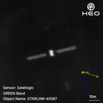
Our first view of a new Starlink V3 in orbit.
Captured on September 30 from approximately 230 km with 34 cm/px resolution, this is an early look at the next generation satellite in the Starlink constellation.
Two solar arrays are deployed, with the spacecraft in an expected orientation as it raises orbit.
The V3s will now move towards their operational altitudes, bringing them closer to HEO’s current network and enabling higher-resolution imagery as they climb.


At T-Minus 5.0 HEO’s CEO & Co-Founder @drwillcrowe explains why we exist, what we mean by becoming the intelligence layer for space, and why better information will be essential to operating in space:
“Our North Star is to image anything in the Solar System on demand.”
“What we realized early on is that we were creating a whole new set of data that no one was set up to handle.”
“We had to take this data, create information out of it, and from that information create intelligence.”
“We need rockets to get up. We need people building satellites. But we also need this intelligence layer so we can actually perform space missions.”
“Space shouldn’t be hard. We just don’t have all the intelligence and information that we need yet.”
HEO's CEO & Co-Founder @drwillcrowe kicked off our fifth T-Minus event, reflecting on a year of major milestones for HEO and introducing the theme of this year’s event: the rise of manoeuvrable space.
From our recent Series B announcement to a new era of satellites changing orbits, following other spacecraft and conducting proximity operations, Will outlined what this shift means for the future of space operations.
Watch his full opening remarks below.
It’s back.
HEO’s T-Minus 5.0 is now live: youtube.com/live/dRkxiT2jtT8…

We’re announcing our US$25M Series B.
HEO’s ambition is to image anything in the solar system on demand. But imagery alone isn’t enough. We need to make sense of what we see and add context for our customers.
This funding will expand our network into GEO, deploy new sensors, grow partnerships and accelerate our software that turns imagery into intelligence.
Thank you to our investors, customers, partners and team for helping us get here.
Read more: heospace.com/resources/stori…

One object. Two RPO campaigns. All angles.
HEO's Continuum-1 satellite spent days in proximity to a noncooperative rocket body, capturing imagery up to 7 cm/pixel across over 50 imaging missions and thousands of individual frames.
This mission moves HEO's capability beyond conventional flyby imaging and provides a foundation for future inspection missions in LEO, while supporting the company's path towards proximity operations in GEO.
More: heospace.com/resources/stori…
@Satellogic @DTBTrailblazer @UNSWCanberra

HEO retweeted

Two Miras — less than 200 meters apart!
Our LEO Express 2 and LEO Express 3 spacecraft recently met for a family reunion in orbit, following a series of carefully coordinated maneuvers that brought the two vehicles within approximately two football fields of each other.
The operation put Mira's flight-proven agility to work, with our GNC, propulsion, and mission ops teams executing multiple complex maneuvers and close approaches along the way.
See how the team pulled it off: lnkd.in/g7kw7RR8
Image credit: @StarfishSpace / @heospace / Impulse Space
Hello there, @GoToImpulse
During Impulse Space’s recent flyby operation, our Holmes Mk2 camera captured imagery of LEO Express 2 at approximately 5 kilometres distance from LEO Express 3.
Huge in-orbit milestone for our Holmes Mk2 NEI camera and the future of spacecraft inspection!
We’ve got the RPO receipt!
HEO has successfully repurposed an Earth observation satellite to conduct Rendezvous and Proximity Operations around a non-cooperative object.
This is one of the first images from the mission.
More: heospace.com/resources/stori…
@Satellogic @UNSWCanberra @DTBTrailblazer

HEO retweeted

Exciting partnership with @heospace to expand their Non-Earth imaging network using our SkySat constellation! Space isn’t just about looking down at Earth - it’s also about looking out into orbit to ensure space domain awareness and safety.

HEO x @Planet
We're integrating Planet's SkySat constellation into our Non-Earth Imaging network, pushing our sensor network past 50 in-orbit sensors for faster revisit rates and more consistent imaging for space domain awareness customers.
Full release: heospace.com/resources/stori…