

Satellite and AI intelligence for every field. 7M+ farmers, 80+ countries, 350+ crops. Free for farms under 1 acre.
New York · Pune
Joined November 2019
- Tweets208
- Following2
- Followers56
- Likes156









Pinned Tweet
We are thrilled to share that Map My Crop has been selected as the winner of The Sustainability100+ Award in the Smart Agro category! The Sustainability 100+ Leadership Awards, presented by AB InBev and Network18 Media . #agriculture #agritech #agristartup #agro
Two fields. Same soil, same rain. One problem was found by walking the field after 18 days of spread. The other was flagged from orbit on day three and contained in 48 hours. Weekly satellite monitoring changes the timing, not the agronomy. Demo: mapmycrop.com/contact-us/
1
90
In August 2025, ISMA joined hands with ADT Baramati and Map My Crop on AI in sugarcane. We are glad to be part of it. linkedin.com/company/map-my-…

2
31
Building your own product? The Map My Crop Crop Monitoring API gives your team satellite and AI crop data, and white-label lets you offer it under your own brand. mapmycrop.com

3
31
We are 55 people with offices and representation in New York, Pune, London, Dubai, Kuala Lumpur and Manila. One product, six time zones, all working on crop monitoring from space. #agritech linkedin.com/company/map-my-…
2
32
Why does a satellite check your field every few days? Sentinel-2 has a nominal 5-day revisit with two satellites. Clouds remove some passes, which is why we draw on 10+ satellite providers, not one. mapmycrop.com
2
29
Lenders and insurers: a satellite can check land under cultivation, crop type, sowing date and crop condition without a site visit. It cannot read a land title or judge intent. We say both. #agritech mapmycrop.com
1
8
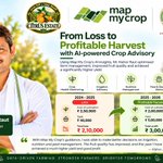
5 acres of citrus at Achalpur, Amravati. 2024-25: a ₹2.1 lakh loss. 2025-26: a ₹3 lakh profit on lower costs and better fruit. Kishor Janardhan Raut, with Map My Crop's advisory. Free for farms under 1 acre.

2
43
We work with ADT Baramati on sugarcane in Maharashtra: satellite monitoring and AI advice by growth stage. The case study figures are vendor-reported and still being confirmed, so we are not quoting them here. #agritech mapmycrop.com
2
30
Our 360° Agro Suite helps farms, plantations, insurers, lenders and governments map land, monitor crops and trees, and anticipate risk across 80+ countries and 350+ crops. mapmycrop.com
4
33
Soybean near Bhopal: 33–50% higher yield, costs flat at ₹15,000/acre. Anand Patidar is taking the same satellite monitoring and stage-wise advice from Map My Crop into wheat next season.

2
20
NDVI flattens in a dense canopy, so a good field and a very good one can read the same. NDRE uses the red-edge band, which reaches deeper into the leaves and keeps responding later. Early season: NDVI. Late and dense: NDRE. #NDVI mapmycrop.com
2
16
G9 banana, 4.29 acres, drip, Solapur. Cost per acre ₹1.5 lakh → ₹1 lakh. 50% less water reported. 90% flowering inside six months. Expected 28 → ~35 t/acre. Dhananjay Rokde's season on satellite advice from Map My Crop.

5
56
Rabi sowing is under way across India. Wheat goes in through November and into December, and mustard is sown earlier. Once seedlings emerge, a satellite can confirm each field has actually come up. #precisionag apps.apple.com/in/app/map-my…
3
42
Farm under 1 acre? Map My Crop is free. Not a trial. You get your field boundary, crop health, weather and irrigation alerts. Larger farms are priced per hectare per year, shown in the app. play.google.com/store/apps/d…
3
36
Map My Crop was founded in 2020 by Neil Jadhav. Our tagline is the brief: satellite and AI intelligence for every field. So far that reaches 7M+ farmers in 80+ countries. mapmycrop.com
3
38
A field boundary from space is a polygon drawn from satellite images instead of walked with a GPS. Crop health, irrigation and loan checks are all calculated inside it, so a wrong edge means wrong numbers. mapmycrop.com
3
33
7M+ farmers, 80+ countries, 350+ crops. That is the reach of Map My Crop today, and the same satellite and AI models run across all of it, from a one-acre plot to a plantation. mapmycrop.com
NDVI is one number per pixel that says how green a field is. Healthy leaves absorb red light and reflect near-infrared, and a satellite measures both. (NIR - Red) / (NIR + Red), from -1 to 1. Higher usually means a denser canopy. #NDVI mapmycrop.com
3
29

Map My Crop retweeted

धाराशिव जिल्ह्यातील परांडा तालुक्यातील चिंचपूर ढगे येथील भूमिपुत्र श्री. सागर जाधव यांच्या Map My Crop या कृषी व Artificial Intelligence (AI) क्षेत्रात कार्यरत कंपनीच्या पुणे येथील मुख्य कार्यालयाला आज पुणे दौऱ्यादरम्यान भेट दिली.
कृषी क्षेत्रात आधुनिक AI तंत्रज्ञानाचा प्रभावी वापर करून शेतकऱ्यांना अधिक सक्षम करण्याच्या दिशेने Map My Crop उल्लेखनीय कार्य करत आहे. देशातील पहिल्या AI तंत्रज्ञानावर आधारित ऊस उत्पादनाच्या कृषी विकास केंद्राचा बारामती येथे झालेला यशस्वी प्रयोगही याच कंपनीच्या तंत्रज्ञानाच्या माध्यमातून करण्यात आला आहे.
यावेळी कंपनीचे सहकारी श्री. राजेश शितोळे यांचीही भेट घेऊन कंपनीच्या विविध उपक्रमांची व भविष्यातील वाटचालीची माहिती घेतली.
माझ्या लोकसभा मतदारसंघातील भूमिपुत्राने उभारलेली ही कंपनी कृषी क्षेत्रात तंत्रज्ञान आणि नवकल्पनांच्या माध्यमातून देशभरात आपली वेगळी ओळख निर्माण करत आहे, याचा निश्चितच अभिमान आहे. Map My Crop ची यशस्वी वाटचाल अशीच दिवसेंदिवस अधिक विस्तारत राहो, यासाठी मनःपूर्वक शुभेच्छा!
नवीन तंत्रज्ञान, संशोधन, नवकल्पना आणि उद्योजकतेला माझा नेहमीच पाठिंबा व सहकार्य राहील. विशेषतः कृषी क्षेत्रातील आधुनिक तंत्रज्ञानाचा लाभ आपल्या शेतकऱ्यांपर्यंत पोहोचवण्यासाठी आवश्यक ते सहकार्य करण्याचा माझा मानस आहे.
यावेळी माझे बंधू मा. जयप्रकाश राजेनिंबाळकर, श्री. नानासाहेब पाटील, श्री. विनायक रणदिवे, डॉ. ऋतुराज कदम पाटील, ॲड. पार्थ पाटील आदी उपस्थित होते.
#MapMyCrop #ArtificialIntelligence #AI #AgricultureTechnology #AgriTech #कृषी_तंत्रज्ञान #नवकल्पना #कृषी #धाराशिव #परांडा #पुणे

