

Storm Services specializes in the design, construction, operation, and management of full base camp setups.
- Tweets8.1K
- Following1K
- Followers413
- Likes634










ALT Current Information & Forecast Positions:Center Location: $25.4^\circ\text{N}, 88.4^\circ\text{W}$ Max Sustained Winds: 105 mph Movement: NE at 14 mph 10 PM Thu: Major Hurricane ('M') 7 PM Fri: Hurricane ('H') 7 AM Sat: Tropical Storm ('S') 7 PM Sat / 7 AM Sun / 7 PM Sun: Tropical Depression ('D') Watches & Warnings Legend:Hurricane Warning (Red): Coastal SE Louisiana, Mississippi, Alabama, and Florida Panhandle. Tropical Storm Warning (Blue): Coastal SE Louisiana and Florida Panhandle. Tropical Storm Watch (Yellow): Inland Mississippi, Alabama, Georgia, and Florida. Map Description: Map showing the 5-day forecast cone for Hurricane Isaias curving northeast from the Gulf of Mexico, making landfall along the central Gulf Coast, and moving inland across the Southeast and Ohio Valley.

ALT Forecast Surge Levels:5-7 ft (Orange): Coastal Alabama and Florida Panhandle through Indian Pass. 4-6 ft (Yellow): Mobile Bay, Ocean Springs, and Indian Pass to Steinhatchee River. 3-5 ft (Yellow): SE Louisiana to Ocean Springs, and Steinhatchee River to Suwannee River. 2-4 ft (Yellow): Suwannee River to Yankeetown. 1-3 ft (Blue): Lake Pontchartrain, Yankeetown to Egmont Key. 1-2 ft (Blue): Morgan City to Mouth of the Mississippi River. Map Description: Coastal forecast map depicting peak storm surge inundation levels above ground level along the U.S. Gulf Coast from Louisiana to western Florida.


ALT National Hurricane Center forecast for Tropical Storm Isaias, issued October 7, 2026, at 10 PM CDT. Isaias has maximum sustained winds of 70 mph and is moving east-northeast at 9 mph. The storm is forecast to strengthen into a hurricane before approaching the northern Gulf Coast Friday evening, with its center potentially moving inland across Mississippi and Alabama Saturday. Hurricane warnings are in effect along portions of the northern Gulf Coast. The cone represents the probable path of the storm's center, not the extent of hazardous conditions.

ALT National Hurricane Center map showing forecast peak storm surge from Tropical Storm Isaias along the northern Gulf Coast. Storm surge of 5–7 feet above ground level is forecast from Ocean Springs, Mississippi, through Mobile Bay, Alabama, to Indian Pass, Florida. Surrounding coastal areas could experience 3–5 feet near southeastern Louisiana, 4–6 feet east of Indian Pass to the Steinhatchee River, and generally 1–3 feet along portions of coastal Louisiana and the Florida Big Bend. Forecast values represent water heights above normally dry ground.


ALT Key Messages: 1. There is an increasing risk of dangerous wind and storm surge impacts along portions of the northern Gulf Coast, and watches could be required on Wednesday. Residents from Louisiana to the Florida Panhandle should closely monitor the latest forecast updates and ensure they have their hurricane plan in place. 2. The system will bring areas of heavy rainfall to the central U. S. Gulf coast Friday into the weekend. Flash and urban flooding, along with isolated river flooding, will be possible. 3. Yucatan Peninsula of Mexico: The depression is expected to strengthen and could bring gusty winds and areas of heavy rain to the western portion of the Yucatan Peninsula in a couple of days.
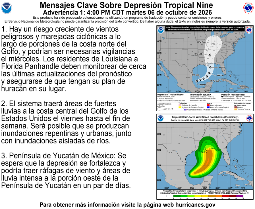
ALT Mensajes clave: 1. Hay un riesgo creciente de vientos peligrosos y marejadas ciclónicas a lo largo de porciones de la costa norte del Golfo, y podrían ser necesarias vigilancias el miércoles. Los residentes de Louisiana a Florida Panhandle deben monitorear de cerca las últimas actualizaciones del pronóstico y asegurarse de que tengan su plan de huracán en su lugar. 2. El sistema traerá áreas de fuertes lluvias a la costa central del Golfo de los Estados Unidos el viernes hasta el fin de semana. Será posible que se produzcan inundaciones repentinas y urbanas, junto con inundaciones aisladas de ríos. 3. Península de Yucatán de México: Se espera que la depresión se fortalezca y podría traer ráfagas de viento y áreas de lluvia intensa a la porción oeste de la Península de Yucatán en un par de días.









ALT High-Impact & Far-Reaching Winter Storm A significant winter storm is underway, with precipitation already impacting the south-central United States. The storm is expected to threaten nearly 180 million Americans with widespread heavy snow, sleet, and freezing rain from the Southern Rockies to New England through Monday. Extremely cold air will follow, prolonging dangerous travel and infrastructure impacts into next week. Widespread Heavy Snow & Sleet Heavy snow is forecast across a large area from the Southern Rockies and Plains through the Mid-Atlantic and into the Northeast. Snowfall totals exceeding 1 foot are likely in parts of these regions. South of the heaviest snow, a corridor of significant sleet accumulations of 1–3 inches is expected. Snow and sleet will create widespread travel disruptions and closures, some of which may persist for several days.


ALT Winter Storm Severity Index. No more important added content to add from what is in the post text.