

Creator of proprietary long-range methods 🌦 Weather: Long Range Forecasting 📈 Markets: Bitcoin • Metals •
Australia
Joined December 2011
- Tweets16.7K
- Following477
- Followers6.2K
- Likes13.8K



Pinned Tweet
What is Cynoptec and what are some of the services offered?
Check out the video below!!
youtu.be/6QY1t0tHsiU?si=ckTb…

☔ 100% CHANCE OF A PRICE DROP.
The one forecast we can promise: 30% off your first year of Weather Pro Plus or Weather Gold, until Wednesday night.
Long-range forecasts that call the event and the date, not just “wetter or drier”. Verified in public after every month.
⏰ A little over 24 hours left.
👉 cynoptec.com/flash-sale
Eligible new and returning members. Terms apply.
#Cynoptec #FlashSale #KnowTheFuture

☔ 100% CHANCE OF A PRICE DROP.
The one forecast we can promise: 30% off your first year of Weather Pro Plus or Weather Gold, until Wednesday night.
Long-range forecasts that call the event and the date, not just “wetter or drier”. Verified in public after every month.
⏰ A little over 24 hours left.
👉 cynoptec.com/flash-sale
Eligible new and returning members. First-year discount. Terms apply.
#Cynoptec #FlashSale #KnowTheFuture #makeweathersexyagain
🤖 Made with AI

🌩️ THE BIG STORM CYCLE IS OVER. WHAT HAPPENS NEXT?
The 19–25 October storm cycle arrived when Cynoptec forecast it would.
Now the pattern is changing.
⛈️ Storms will continue across much of Australia, but they're expected to become more isolated and less intense.
🌡️ Mid-November brings a forecast hotter, drier phase, with Stu warning that national heat records could be tested across the interior.
🌩️ The next widespread storm systems aren't expected until the second half of November.
And here's the important part.
Stu explains that Cynoptec's long-range forecasting focuses on WHEN the rain is expected to arrive, not just what ENSO and other background climate drivers suggest.
That's the thinking behind what we've been building.
Want to see the forecasts for yourself?
🔥 OUR 48-HOUR FLASH SALE IS ON NOW!
Get 30% OFF your first year of Weather Pro Plus or Weather Gold.
⏰ Ends Wednesday 28 October at 11:59 pm AEDT.
👉 cynoptec.com/flash-sale
CYNOPTEC: KNOW THE FUTURE™
Eligible new memberships only. First-year discount. Terms apply.
#Cynoptec #AustralianWeather #LongRangeForecast #StormSeason #WeatherIntelligence

Cynoptec retweeted
🚨 OI. YOU. YES, YOU! 👀
For 48 hours: 30% OFF your first year of Weather Pro Plus or Weather Gold, with the Cynoptec Climate Intelligence Model.
⏰ Ends Wednesday at midnight.
👉 cynoptec.com/flash-sale?utm_…
Eligible new and returning members. Terms apply.
#FlashSale #KnowTheFuture
🤖 Made with AI

Cynoptec's Climate Intelligence™ forecast vs reality
From 21 to 26 October, the new Cynoptec long-range model had an inland system sweeping through the interior, South Australia Victoria and NSW.
The result? Falls landed right on target. Northeast Victoria around 30 mm. Victoria 35 to 40 mm. The Riverina 17 to 20 mm.
Storm season is tricky. One postcode cops 100 mm while the farm down the road gets under 5 mm. That’s why Cynoptec gives you a central value for the typical rain, plus a wide range for when the severe cells fire up.
And the storms aren’t done yet. Into the end of the month they shift east and northeast. Southeast and Central Queensland, Northeast NSW, the Warrego and Darling Downs are next in line for 15 to 30 mm, with isolated severe cells capable of 100 to 150 mm. Intense little storms are also possible through NSW troughs, parts of SA and interior WA.
Is your paddock next? Watch the full breakdown and get the long-range forecast at cynoptec.com
Cynoptec - Know the Future™
One of the strongest El Niño events on record. Positive Indian Ocean. Every textbook said dry spring for the east.
The ABC now reports 2026 is on track to be Australia’s wettest El Niño year on record, the first in 27 El Niño years since 1900 with above-average winter-spring rain.
Cynoptec members knew the forecast as early as March 2026.
The 19 to 25 October High Energy Period arrived on schedule. Rainfall recorded across all states and territories.
Cynoptec does not forecast from the background drivers and that's our advantage. The long range forecast identifies when the weather is due and how it should form, and then it does - right on cue.
This week:
Wed 28 Oct: severe storms and the season’s first real hail risk through Central Queensland, the Coalfields, Mackay Whitsundays, Wide Bay and the Southeast Coast
Thu to Fri: the next trough drops through the SA pastoral districts into the Mid North and South East
Sat 31 Oct to Sun 1 Nov: the storm cycle returns through the Riverina, Central West and Northwest Slopes and Plains and into Victoria
First week of November: storms continue for inland Queensland, NSW and Victoria
WA dries out, right on its normal schedule
Frost risk low, isolated light frost only in the highest alpine and Tasmanian valleys Tue and Wed
Then mid-November heat, records likely tested through the interior, and the main event from 25 November into early December. Heavier than October. That one is already on the map too.
If you want the dates before the next one lands, this is the week to get in. For 48 hours only, 30% off your first year of Weather Pro Plus or Weather Gold, full access to the Cynoptec Climate Intelligence Model and everything it has mapped ahead. Ends Wednesday midnight. Eligible new and returning members, first-year discount, terms apply.
Flash sale: cynoptec.com/flash-sale
Members, this week’s full forecast, district rainfall tables and the week-by-week timeline: cynoptec.com/forecasts/d4979…
Cynoptec - Know the Future™
#Cynoptec #WeatherIntelligence #FlashSale #AustralianAgriculture #knowthefuture

🚨 OI. YOU. YES, YOU! 👀
For 48 hours: 30% OFF your first year of Weather Pro Plus or Weather Gold, with the Cynoptec Climate Intelligence Model.
⏰ Ends Wednesday at midnight.
👉 cynoptec.com/flash-sale?utm_…
Eligible new and returning members. Terms apply.
#FlashSale #KnowTheFuture
🤖 Made with AI


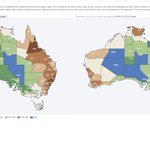
October scorecard, 25 days in: forecast on the left, recorded on the right.
Every Cynoptec monthly outlook is published in actual millimetres, district by district, and locked before the month begins. No probabilities to hide behind or quiet revisions. Then our Outlook vs Actual page scores it daily against recorded Bureau of Meteorology station data, both maps on the same colour scale so your eye does the judging.
The standout: before October began, we called an exceptionally wet month through the interior, with several pastoral districts forecast at more than three times their October average. Twenty five days in, those districts are recording 324 to 446 percent of average. A 300 percent call, made in millimetres and locked in advance, verifying in the 300s and 400s, is the kind of result this system was built for.
Across the rest of the country: the west, a close hit. The west interior, a close hit. The Northern Territory, a close hit. South Australia, a close hit. Queensland and New South Wales have run wetter than forecast, with the biggest overshoots in drought affected areas of the east, exactly where above forecast rain is most welcome. With more rain closing out the month, the remaining southeast gaps are likely to finish near expected while the eastern drought districts finish well above.
On the misses, perspective about scale: where a district has missed, the gap is often within 10 mm of the forecast range. The larger gaps have come from localised flooding rain, single storm totals that lift one gauge far beyond what the district as a whole received.
Committing to district rainfall in millimetres, months ahead, then publishing the verification in public, is the hardest challenge in long-range forecasting. It is a benchmark very few in the industry attempt, and we are clearing it month after month.
Explore the outlooks, out to December 2027: cynoptec.com/dashboard/clima…
Cynoptec - Know the Future™

Most long-range outlooks tell you the odds. Ours tells you the millimetres, then marks its own homework.
Seasonal forecasts are usually issued as probabilities or anomaly categories: a 65 percent chance of above median, a lean to wetter. Useful, but hard to plan a season around, and even harder to verify in a way a farmer can see.
Cynoptec publishes its monthly outlook in actual rainfall, district by district, locked before the month begins. Then our Outlook vs Actual page scores it daily against recorded Bureau of Meteorology station data, side by side on the same colour scale, where every member can watch it verify or miss.
Here is October 2026 to the 24th. The east has run wetter than our outlook, while the west, interior north and south are tracking within expectations. Totals to the 25th update tonight, automatically.
Forecasting in millimetres is a higher bar than forecasting in probabilities. We hold ourselves to it because that is the number a sowing, spraying or harvest decision actually needs, and because a forecast you can score is a forecast you can trust.
Explore the outlooks, out to December 2027: cynoptec.com/dashboard/clima…
Cynoptec - Know the Future™

New tools just landed in Climate Intelligence.
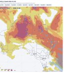
The Live Models panel has had its biggest upgrade yet. You can now run the world’s two leading weather models side by side, ECMWF and NOAA GFS, across the full set of views: rain, pressure, thickness, winds at three levels, temperatures, dewpoint, storm potential, mid-level moisture and more. One click flips between models on identical scales, so you can see where they agree and where they split.
And the one we think farmers will use every day: the new Location plot. Type your town, press Enter, and get a 10-day daily rainfall chart showing ECMWF, GFS and the two-model average for your exact spot. No more reading maps to find your place.
It all updates itself twice a day from the latest global runs, and the Outlook vs Actual page keeps scoring our monthly outlook against recorded rain as the month unfolds.
Cynoptec - Know the Future™


Cynoptec retweeted

⚠️‼️Look out! We just got magnetic level 7+ alerts from magnetometers around the world! Something big may be about to happen. Moon just crossed the Eurasian Plate to the Indian Plate and Antipode crossed to the Nazca Plate. Could be an upcoming solar flare or a big earthquake. The M 5.2 quake in Afghanistan does not seem to be big enough to be the resolution of these alerts.

Cynoptec retweeted

350mm effective rainfall, 160 units of nitrogen, 27 bales to the ha... 😬
Cheers Kevin Scott for the bailing job! Wasn't getting far between bails 😅


Cynoptec retweeted

The headwaters of the Maranoa River are on the move! 🌧️
Not everyone gets to witness the incredible sight of rain turning into flowing rivers across the Queensland countryside.
It’s one of those special sights that reminds us just how amazing life in the bush can be!
Are we relying too heavily on climate indicators?
New research in the Journal of Climate found that ENSO, the IOD and SAM combined explain up to about 45% of Australia’s seasonal rainfall variability, and that is in the regions and seasons where their influence is strongest. Across most of the country and most of the year, it is considerably less.
More than half of what actually falls is driven by something else.
Yet El Niño and La Niña still dominate the seasonal conversation, and industries that live and die by rainfall are left treating probabilities as predictions.
This article looks at what the research says, why it matters for agriculture and other weather dependent sectors, and where long range forecasting needs to go next.
Read the full article: linkedin.com/pulse/we-relyin…
Cynoptec - Know the Future™

ONE SCREEN, TWO HORIZONS.
Climate Intelligence now pairs our long-range outlooks with live ECMWF model guidance, built into the same viewer. The long-range calls the windows months ahead. The new EC panel then sharpens each window as it arrives: daily rain to 10 days, wind, temperatures, rain vs normal for your district, and cyclone tracking with the full ensemble spread. Updated automatically twice a day.
The panel launches in beta, with map resolution and new features improving as updates drop over the season.
Members: live now at cynoptec.com.
Cynoptec - Know the Future™
