

Geomni- Imagery and data for mapping professionals. #GIS #geospatial #lidar #mapping .
Utah, USA
Joined May 2018
- Tweets356
- Following2.2K
- Followers488
- Likes518

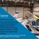




Come visit our booth @GITAssociation Pipeline Technology FORUM in #Houston TX. Let's talk about the data that you need to make your project a success! We specialize in airborne imagery and data acquisition, warehousing & licensing. #lidar #aerialphotography #gis #mapping🗺️📸🛩️

1
Come visit us at our table @GITAssociation . Let's talk about what our huge #aerialimagery database can do for your project! #lidar😃
This quoted post is unavailable.
1
Love to see data in action!

Our #3DImageofTheWeek is a 3D flight simulation - DFW 35C touch & go. Imagery provided by @GeomniMapPros. Simulation created using #TerraExplorer. #Skyline
1
🛩️Experience the Geomni Advantage.
We have over 100 fixed-wing aircraft and helicopters all equipped with the best remote sensing technology available.
😎Claim your free sample data set here:
https://xitter.gq/t.co/6T0AHBdBDm
#geospatial #geospatialdata #gis #lidar #aerialdata #mapping

Conversation provides the opportunity for growth, respect and productivity. #WellnessWednesday
1


We have some reps @nsgic. Looking forward to hearing about the insightful conversations!


How you feel about your project when you harness the power of one of the largest geospatial companies in the United States🛩️😍 #WellnessWednesday #GeomniPSM #LiDAR #geospatial #Photogrammetry #Surveying #mapping
Happy Labor Day! Enjoy your time with family and friends 🤩 #LaborDay #LaborDayWeekend
2
The holiday weekend is coming up fast! What kind of exploring adventures are you planning? #FeelGoodFriday
#GoGeomni
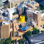
🛩️Creative architecture and execution. Check out our view of the Ray and Maria Stata Center #MIT designed by #FrankGehry⠀⠀⠀
👍Free Samples and trial software here https://xitter.gq/t.co/6T0AHBdBDm
#geospatial #gis #lidar #aerialdata #mapping #3Ddata #urbanplanning #aerialphotography

ALT franck gehry stata building MIT
Ultimate #TBT

A (very) brief history of plate tectonics. Watch the continents take shape here: p.ctx.ly/r/9jf9 #gis #geography
Great opportunity for students!

Attention students: volunteers need for #GISPro in #NewOrleans! Network and meet professionals in the #geospatial community. Volunteering earns you free registration to the conference! Deadline to sign-up is August 30th! @URISA #GIS

Mapping is truly an art✈️🗺️
You’re unable to view this Post because this account owner limits who can view their Posts. Learn more
1
Nothing like the pen and paper in a mappers hand!
This Post is from an account that no longer exists. Learn more
Inspired use of 3D data. #TBT

With someone's beautiful concept of El Castillo, I use tricks to create the 3D environment entirely via @ArcGISPro . Doing some film matte painting work years past gave me a few tricks to emulate the look a bit. #esri #gis #animation #mattepainting #3D #Yucatan #chichenitza
1
🛩️Experience the Geomni Advantage.
We have over 100 fixed-wing aircraft and helicopters all equipped with the best remote sensing technology available.
😎Claim your free sample data set here:
https://xitter.gq/t.co/6T0AHBdBDm
#geospatial #geospatialdata #gis #lidar #aerialdata #mapping

We honor #AmeliaEarhart , one of the leading pioneers of international aviation, on #WomensEqualityDay ✈🤩
2
We support #WomensEqualityDay and are proud of the gender diversity in our pilot program. 🛩️👩🏿🦱👩🏾🦳👩🏽👩🏼🦱👩🏻👩🦱
This quoted post is unavailable.