

Geomni- Imagery and data for mapping professionals. #GIS #geospatial #lidar #mapping .
Utah, USA
Joined May 2018
- Tweets356
- Following2.2K
- Followers488
- Likes518







Geomni Aerial Imagery retweeted

We have multiple state of the art sensors operating in Europe. They are capturing imagery to use with our award-winning #geospatial data & analytical solutions. #aerialphotography #aerialsurvey #data #Geomni #Midas #camera
Geomni Aerial Imagery retweeted

One of the best things I heard at @URISA #GISPro2019: "I love how the members support and empower each other and how the women in URISA I've met build each other up." URISA offers such a wonderful environment to learn, grow, and succeed!!
#GIS #Geomatics #GetInvolved @URISAVC

Geomni Aerial Imagery retweeted
#Reminder - we'll be running a #webinar 12th November - "Understanding Urban Environments". A detailed understanding of both built & natural environments are critical to #city #planning and improving the health and well being of citizens. Register here https://xitter.gq/t.co/TKYTMb50ex

Geomni Aerial Imagery retweeted

Incredible to hear from over 40 states about their successes, challenges, and goals at the #RollCallofStates. There's a ton of #data and #GIS progress being made. #NSGIC19

Cy Smith, GIO for Oregon, reports out on our work with #gis and #EM for @OregonOEM at the #RollCallOfStates at #NSGIC19! @EsriDRP @EsriSLGov @ArcGISStoryMaps @GISPublicSafety #EMGTwitter
Geomni Aerial Imagery retweeted
The #Geomni Viewer is our online portal and accessible web mapping service. It makes accessing your #aerialphotography #aerialsurveys really easy. Just login into our cloud hosted service. #GIS #geospatial #BigData

Geomni Aerial Imagery retweeted

The #RCAT #TexasRoofingConference is only 1 day away. Come say hello to Geomni at booth #126 and we'll show you some of the ways you can get fast roof measurements. #roofing #construction #contractors #texas
Geomni Aerial Imagery retweeted
Today is the 18th anniversary of the 9/11 attacks. Geomni honors those brave souls who lost their lives that day. #Honor911 #NeverForget

Geomni Aerial Imagery retweeted
Take a look at our UKMap dataset - it is a highly detailed and feature-rich mapping database which has been used by key commercial and public organisations including Tfl and Met Police. geomni.co.uk/ukmap

Geomni Aerial Imagery retweeted
Tropical Storm #Dorian has picked up strength with winds now up to 70 mph. Forecasted to become a hurricane soon.

External rain bands from Tropical Storm Dorian are beginning to affect Culebra, Vieques and moving over northern municipalities of PR.
Bandas externas de la Tormenta Tropical Dorian están comenzando a afectar Culebra, Vieques y se mueven sobre municipios del norte de PR. #prwx
Geomni Aerial Imagery retweeted
Visitors to the Historic Casey Jones Home & Railroad Museum can climb aboard "Ol' 382" stationed outside of the museum, the engine Jones was operating on his fateful last run. #caseyjones #museum #railroad #tennessee #aerialimagery

Geomni Aerial Imagery retweeted
The Airbus A380's wingspan - 261 feet - is longer than its total length of 238 feet. #airbus #A380 #aircraft #FastFactFriday
Geomni Aerial Imagery retweeted
The @FloridaGators were victorious over the Miami Hurricanes in this past Saturday's NCAA opening game. #ncaafootball #stadium #aerialimagery

Geomni Aerial Imagery retweeted
#DidYouKnow - our UKMap dataset was used by the Met Police in the 2011 London riots to identify buildings where people were living above shops. This information allowed them to deploy their resources in the areas of highest risk. #data #buildings #UKMap #GeomniUK

Geomni Aerial Imagery retweeted
We can see #GoosePointFire burning from our windows.

Here's a timelapse of the hazy skies we have seen this morning as smoke from the #GoosePointFire makes its way into the Salt Lake Valley. #utwx #uofu
Geomni Aerial Imagery retweeted
#SaveTheDate - 11th-12th September we'll be at the British Cartographic Society/Society of Cartographers Annual Conference. @bcsweb. We're proud to be sponsoring the event which offers insightful talks as well as great networking opportunities. #maps #mapping #GeomniUK


Geomni Aerial Imagery retweeted

Great to team up with @GeomniMapPros as Silver sponsors at this year's FOSS4G UK in Edinburgh, 19-20 Sep. #foss4guk2019 Tickets out now: eventbrite.co.uk/e/foss4guk-…
More info: uk.osgeo.org/foss4guk2019/
#GIS #geospatial #lidar #mapping #AerialImagery

Geomni Aerial Imagery retweeted
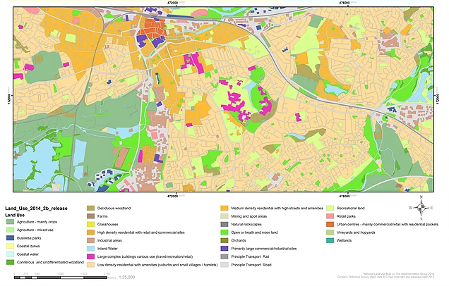
We'll be running another #webinar 12th November - "Understanding Urban Environments". A detailed understanding of both the built & natural environments are critical to #city #planning and improving the health and well being of citizens. Register here https://xitter.gq/t.co/TKYTMaNoPX
Geomni Aerial Imagery retweeted
Owned by the city of Pittsburgh since 1893, @PhippsNews became a privately managed, city-owned nonprofit on its 100th anniversary in 1993. #aerialimagery

Geomni Aerial Imagery retweeted
Researchers are predicting a near-average Atlantic hurricane season featuring six forecasted hurricanes. Of these, two will be major hurricanes.
This Post is from an account that no longer exists. Learn more
Geomni Aerial Imagery retweeted
#Emergency #Response teams - how well do you know your area? Could our #data sets assist you with more detailed knowledge so that you can be better prepared in case of an incident such as Whaley Bridge or Grenfell? #data #buildings #land geomni.co.uk/products
