

Map illustration - all genres and applications where maps can tell a visual story - multiple styles, techniques and approaches. https://xitter.cf/t.co/LHMy7updji
Islington, London
Joined October 2011
- Tweets539
- Following52
- Followers4.3K
- Likes6.3K




Released today in the UK. ‘The Burning Earth’ by Sunil Amrith. Published by W W Norton, illustrated maps by Hand Made Maps. An examination of the world’s dwindling resources, exploitation, and the inevitable consequences.
@amrith_historian @yale_history @wwnortonuk


Released today in the US. ‘The Burning Earth’ by Sunil Amrith. Published by W W Norton, illustrated maps by Hand Made Maps.
@sunilamrith @yale_history #ecology #humangeography #theburningearth @WW_Norton


On the personal work front, my drawing 'Il Grande Cavallo 1482' has been awarded the Critics Prize at the Annual Exhibition the Royal Society of British Artists. On show at the Mall Galleries until Saturday 9th March.

Released 7th November 'The Picnic : A Dream of Freedom and the Collapse of the Iron Curtain' by Matthew Longo @matthewblongo Published by @wwnorton (interior maps by Hand Made Maps)


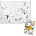
Released this week by @wwnorton in the US 'Endangered Eating :America's Vanishing Foods' by Sarah Lohman - Illustrated map spread by @HandMadeMaps #food #History #illustrationart #endangeredeating #inkdrawing – at Islington, London

Private Commission: Illustrated map of the River Test in Hampshire and the origins of dry fly-fishing. inks/watercolour/coloured pencils. >swipe left to see artwork develop from initial masking to final state >swipe again for close-up video.
#illustratedmap #rivertest #flyfishing – at Islington, London

Released this week 'Palatine' by Peter Stothard. Map artwork by @HandMadeMaps - hand lettered in original roman characters. @orionbooks @OUPAcademic @PeterStothard1 #handmademaps #romanlettering #ancientrome #lettering #interiormaps #palatine #maps #bespokemaps

er, wasn’t the style used as a reference to where and when democracy originated? These buildings signify that they are the guardians of democracy - the least worst political system.
Period map artwork for ‘Venetian Gardens’ by @themontydon and @moorederry published by @penguinrandomhouse October 22. (swipe to see rest of double page spread). #bbcbooks #montydon #derrymoore #venetiangardens #penguinbooks #venice #periodmap #mapartwork #handmademaps #gardening

Published 22.02.23 by Unicorn @UnicornPubGroup 'An Irishman Abroad: Growing Up with Unity and Division in an Anglo Irish Family' by Tarka King #BookTwitter #ulster #UlsterCanal #badlands #NorthernIreland #Cyprus #MapArtwork


Congratulations to Bob Newman 🎩 ! First Prize and Gold Award at Tokyo International Foto Awards for ‘Shadows of Emmett Till’. Published by Kehrer Verlag. Illustrated map by Hand Made Maps. #bobnewmanphoto #magdalenasole #kehrerverlag #till #emmetttill #tokyofotoawards #tokyofoto – at Islington, London


Hand Made Maps retweeted

My piece for today’s Observer:
theguardian.com/commentisfre…

Friday 22nd = Earth Day - released today in the UK, illustrated by Hand Made Maps : “Ever Green : Saving Big Forests to Save The Planet” by John W Reid and Thomas E Lovejoy. #wwnorton #illustratedmap @WorldForests #worldforests #biodiversity #amazonrainforest #earthday – at Islington, London


Published today by Weidenfeld & Nicholson , illustrations by Hand Made Maps : “Not Far from Brideshead: Oxford between the Wars” by Daisy Dunn @DaisyfDunn @wnbooks @orion_art_dept #notfarfrombrideshead #oxford #oxforduniversity #oxfordshire #illustratedmap – at Islington, London


Published this week in the US, illustrated by Hand Made Maps : “Ever Green : Saving Big Forests to Save The Planet” by John W Reid and Thomas E Lovejoy. #wwnorton #illustratedmap #forestconservation #forests @wwnorton #worldforests #biodiversity #amazonrainforest


Released today. 'The Hero's Way' by Tim Parks, illustration by Hand Made Maps. published by Harvill Secker. A 400 mile hike following Garibaldi's retreat from Rome in 1849. @timparksauthor @harvillsecker #timparksauthor #garibaldi #walking #hiking #illustratedmap #illustration

Released 21st Jan 'The Festival' by @SarahJNaughton > illustrated by Hand Made Maps #thriller #festival #festivals #thrillers #books #booksofinstagram #bestsellers #Bestseller @trapeze_books @orionbooks #illustratedmap #illustratedmaps #TheFestival

Released last September 'Dead Doubles' by Trevor Barnes. maps and charts by Hand Made Maps #deaddoubles #portlandspyring #trevorbarnes @wnbooks #londonmap

Published today ‘Sovereign of the Isles’ by Iain Milligan pub. @UnicornPubGroup Maps throughout by Hand Made Maps. A History of Britain told through the changing ownership of land. Ties together many historical reference points. – at Islington, London


