
OpenStreetMap South Africa
South Africa
Joined September 2016
- Tweets112
- Following105
- Followers252
- Likes138




🚀 Our sister project alltheplaces.xyz/ is expanding rapidly in South Africa! 🇿🇦 Recently added: Spur, Lewis Stores, Ackermans, Vida e Caffè, Capitec, Mochachos & LEGiT. Developers, ready for a challenge? What should be next? 🤖🌍 #Python #ZA
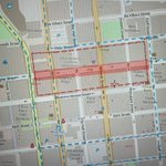
Kudos to the @CityofJoburgZA for using #OpenStreetMap in the #JoburgExplosion response. How about allowing us to use your recent aerial & oblique photos to help us improve our mapping? #GIS #Aerial 🇿🇦🗺️📷

ALT Screenshot of OpenStreetMap map showing central CBD of Johannesburg. Dashed red line overlay around the area affected by the Joburg explosion.
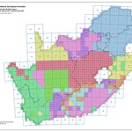
The Chief Directorate: National Geo-spatial Information has over the last 5 years captured high resolution aerial photos (25cm/pixel) of the whole of South Africa. We've recently received a copy and will soon make the photos available to mappers. 🇿🇦📷 community.openstreetmap.org/…

ALT Aerial photo showing Ystervarkkop @ -32.0363,20.223. Eathy enhanced colours.
New South African 25cm resolution aerial imagery? Yes please! Work in Progress: community.openstreetmap.org/…

ALT CD:NGI map with grid of coloured squares showing when aerial imagery was flown for particular parts of the country (By Jan 2023). All imagery captured from 2017 onward was captures at 25cm resolution. Prior imagery was 50cm. Nearing full 25cm coverage.
We have 2x new South African MapRoulette mapping challenges. Can you 🫵 help us improve the map? ❤️ community.openstreetmap.org/…
🪜⬆️🇿🇦🌍🗺️

Article about us mapping the South African Electricity Network xitter.cf/TechCentral/status/161… ⚡️🗺️🇿🇦 #Eskom @EskomSePush @firefishy1 #OpenStreetMap


We now have a Whatsapp OSM South Africa group: chat.whatsapp.com/GFTGNQdFJ3… 🇿🇦🗺️
What South African companies uses #OpenStreetMap? @TelkomZA, @Clicks_SA, @MWEBTweets, @Vodacom, @Hollard, @PostNet, @DRDLR_online, @ChickenLickenSA, @ICASA_org & @IECSouthAfrica to name a few. Not bad for a non-profit volunteer made project. You can help us map Mzansi too! ❤️🇿🇦🗺️
OpenStreetMap ZA retweeted

Registration is open for the OSM Africa November Mapathon to #MapCameroon with GeOsm_Family @OSMCameroun and #KidsAndGirlsInGeospatial on 12th November.
Get your free ticket now and spread the word eventbrite.com/e/osm-africa-…

OpenStreetMap ZA retweeted
We had a great time mapping South Africa with @OpenStreetMapZA @UPmappers and #Sovenga @youthmappers
Thank you everyone who turned up, mapping continues for the rest of October on these projects
tasks.hotosm.org/projects/13…
tasks.hotosm.org/projects/13…


OpenStreetMap ZA retweeted
See who is coming to the OSM Africa October mapathon to #MapSouthAfrica with @OpenStreetMapZA @UPmappers @ULvarsity on Saturday 8th.
You can still join us, register here eventbrite.com/e/osm-africa-…

We're trying something a little different to reach new mappers. We are running a sponsored twitter $ promotion to reach new mappers using this tweet: xitter.cf/OpenStreetMapZA/status… Is there something else we should try?

Noticed something missing in #OpenStreetMap? Use every-door.app to add it directly to the map from your cellphone. 🇿🇦❤️🗺️📱 #ios #android
Noticed something missing in #OpenStreetMap? Use every-door.app to add it directly to the map from your cellphone. 🇿🇦❤️🗺️📱 #ios #android
OpenStreetMap ZA retweeted
Registration is open for the OSM Africa October online mapathon to map South Africa in conjunction with @OpenStreetMapZA, @UPmappers & @ULvarsity #YouthMappers
Get your free ticket now eventbrite.com/e/osm-africa-…

Hot off the press... We now have a dedicated OpenStreetMap South Africa community forum: community.openstreetmap.org/… #osm #za 🇿🇦❤️🗺️
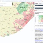
Ever wondered what #Eskom's power distribution grid looks like? Check out: openinframap.org/#6.16/-28.3… Found anything missing? Add it to #OpenStreetMap #Loadshedding @Eskom_SA
New tool to help us workout what tags to use for a particular type of road
westnordost.github.io/osm-le…

OpenStreetMap ZA retweeted

This looks like exactly the tool I have been looking for to update the admin boundaries!
The @CityofCT has an amazing collection of historical aerial photos of the city from 1926 to the present. They can be viewed online here: grant.dev.openstreetmap.org/… 🇿🇦🗺️❤️