

Southern Oregon and Northern California weather updates. My website links to weather data live from Medford, Oregon. Hourly weather updates 24/7/365.
Medford, Oregon
Joined April 2009
- Tweets143K
- Following132
- Followers2.3K
- Likes1.3K






A glimpse of fresh snow and some blue skies intermixed at Mt. Ashland, courtesy of the Comer Chair webcam.

It is a beautiful sunrise at Crater Lake National Park and on the Steel Visitor Center webcam this morning. It is great to see the snow beginning to pile up across the Cascades.

17
359
Another front is expected to arrive later in the day on Saturday into Sunday. Here is a look at the initial rainfall estimates through early morning Sunday.

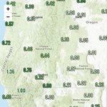
The 72 hour observed precipitation amounts shows where the bulk of the heavier rainfall has been focused over the last few days.

Radar returns this morning are picking up on a few showers moving inland and across portions of the region. Most of this is focused across Northern California. All winter hazard bulletins have expired.

High temperatures today will remain on the cooler side as we are the back side of a trough over the region. We should see more more sunshine develop later in the day. Here are the latest projected highs.

The front continues to meander east and southeast across portions of Northern California this morning. There are still a few showers across portions of the forecast area. The rest of the region is seeing areas of fog and low clouds develop overnight into this morning.

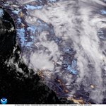
The northeast Pacific satellite imagery shows a slow moving cold front shifting to the east over our region. Showers have been progressing inland throughout the day. The low will take a track southeast into California.

We are likely to see fog and low clouds develop overnight across the interior valleys. We could see a few areas of dense fog. Here is the latest risk map from the NWS in Medford.

RyanWeather.Com retweeted

Utqiaġvik (Barrow) will officially enter Polar Night once the sun sets later today at 1:42 PM. The sun will not rise again until January 23, 2027. While the sun will remain below the horizon for the next 65 days, they will still see a few hours of civil twilight each day. #akwx

ALT Utqiaġvik (Barrow) will officially enter Polar Night once the sun sets later today at 1:42 PM. The sun will not rise again until January 23, 2027. While the sun will remain below the horizon for the next 65 days, they will still see a few hours of civil twilight each day. #akwx
The snow is stacking up at Mt. Ashland today. Here is a look at the Lodge webcam late this morning. No word on snow depth at this time but we are starting to see an early base form.

A great look at the trailing cold front moving inland this morning. A much colder airmass is moving inland behind the front with plenty of cold air cumulus instability clouds. This will bring more shower activity heading into today.

It is snowing moderately across the Cascades this morning. The Crater Lake webcam and ODOT Trip check webcams show current conditions as of 6 AM this morning.


Here is a look at radar returns showing where showers are moving inland this morning. The cold front is progressing east/southeast across the region.

A look at projected snowfall amounts across the region through 4 AM tomorrow morning. For a full list of winter weather headlines please click the link below.
weather.gov/winter?sid=mfr

High temperatures today will trend even cooler. Here is a look at the latest GFS model run projections across the region.

Visible satellite imagery this morning shows the cold front progressing inland across the region. We have seen winds begin to drop off slightly at the coast, but remain gusty for inland locations. Precipitation of also increasing from west to east.

Cold air cumulus clouds near the center of the low offshore is generating plenty of lightning activity. You can see this on the latest lightning detection over the last half hour.


Satellite imagery and radar returns are showing the outer bands of the cold front getting closer to the coast. We will see winds begin to ramp up heading into the evening and overnight hours as well as increasing precipitation.


