

SWCT/NY, Metro Weather Service & National Weather Forecasting, Inc. Now all under one roof; we are your source for point specific forecast needs!
Northeastern USA
Joined September 2011
- Tweets25.5K
- Following128
- Followers11.6K
- Likes1.2K




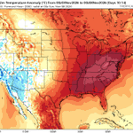
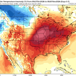

Our El Nino is raging! Ocean surface temperatures a bit above 3 degrees C in the Nino region 3.4 which is towards the central Pacific along the Equator.


SWCT/NY Weather retweeted
3:43pm CDT #SPC_Watch WW 698 TORNADO MN WI 282040Z - 290200Z, #mnwx #wiwx, spc.noaa.gov/products/watch/…


Unusual severe thunderstorm setup this afternoon across the northern Mississippi River Valley. Damaging wind gusts & a few tornadoes the main risk with large hail a bit less. 4 pm-midnight eastern

SWCT/NY Weather retweeted
7:15am CDT #SPC Day1 Outlook Slight Risk: this afternoon and early evening from central Minnesota into northwest Wisconsin spc.noaa.gov/products/outloo…




nationalweatherforecastingin… We offer forecast for all needs!

Subscribe from anywhere! We are looking to expand outside of our current coverage area as well as within!
nationalweatherforecastingin…


SWCT/NY Weather retweeted

SEVERE WEATHER LIKELY NEXT WEEK November 2-3!
The most potent upper-level trough we have seen since spring is forecast to eject across the southern Plains and Dixie Alley on November 2-3. Instability looks a little marginal on the global models so far, but that is par for the course this time of year.
We are watching the southeastern Great Plains on November 2 and east across Dixie Alley on November 3 for the possibility of big severe weather and tornadoes.
Stay tuned for updates!

SWCT/NY Weather retweeted

The dissemination of AIFS/ENS is now corrected to its previous form, completing within minutes.


