

I forecast significant weather in DC & the Mid-Atlantic. GMU and PSU alumnus, Cat dad and Photographer. Instagram: dc_storms
Washington, DC
Joined May 2021
- Tweets10.2K
- Following715
- Followers1.2K
- Likes8.8K


🇺🇸DC🍁Storms retweeted

There's nothing wrong showing a 7-day snowfall map of an upcoming storm within context of uncertainty e.g. what's the current % chance of 6" of snowfall?
Posting > 7 day GFS maps is "clickbait" and also unprofessional and sloppy.
It's a valuable public service to point out egregious examples and help remediate if at all possible -- as an educational opportunity. However, there's no excusing ignorance by TV meteorologists or consulting outfits.

🇺🇸DC🍁Storms retweeted

00z EPS continues the trend of backing the trough up West. This means an even more widespread shot of cold air along with a higher chance of a strong storm system. This strong storm risk will be a Winter storm for favored areas.
🇺🇸DC🍁Storms retweeted

First snowfall of the season for the interior northeast looks like it has merit to me for early next weekend. The upper air pattern supports a coastal low that can produce accumulating mountain snow. I would not buy any models that show some closer to coasts as there's no deep cold air out ahead. This time of year strongly favors mountains of New England


🇺🇸DC🍁Storms retweeted
My 2026–27 Winter Forecast ❄️
This is a summary, a video will follow next week.
Forecast Summary Discussion:
This fall's El Niño is at record levels and a strong El Niño usually means a mild winter across the North. As an example, the 2024 nino was the warmest Northeast winter on record. This year I'm leaning against that warm consensus. The PDO is firmly negative (rare in El Ninos) and the QBO winds in the tropical stratosphere are close to the fall 1957 El Nino. The early season polar vortex is running slightly weak, and models forecast a displacement toward Hudson Bay around Halloween. Euro weeklies are also hinting at a ridge in eastern Gulf of Alaska/west Canada where warmer years had a trough at this point. I weight fall observations heavily.
This initially could mean a colder late Nov into early Dec before vortex strengthens again causing mid-late Dec though Jan to be warm in east with typical strong nino conditions dominating. The key then comes down to if we get a mid to late winter stratospheric warming.
Due to these current observations, I've moved off my initial thoughts of a very warm 1997/1982-led analog blend toward 1957–58, 1972–73, 1965–66 and 1969–70, keeping 1997–98 at a lower weight. Its bold, but that's the forecast.
TEMPERATURES
• December: near to slightly below normal in the East and South (Northeast about −0.7°F), milder in the northern Plains.
• January: the mild month, about +2 to +3°F in the Northeast, as the vortex recovers and the Pacific jet takes over.
• February: the core of winter. 4 of my 5 cold analogs had a major sudden stratospheric warming in Jan–Feb, including late January in 1958 and 1973.
• Overall: near normal to slightly cold in the East, colder than normal in the South.
SNOWFALL:
• Above normal (125–150%+ ) from Texas and Oklahoma through Tennessee, Virginia and North Carolina.
• Near to above normal in interior New England. I have the I-95 corridor near normal (90–110%)
• Below normal (50–75%) across the northern Plains, Upper Midwest and Great Lakes, and 75–90% in the northern Rockies.
• February is the wild card. Feb 1958 buried the Northeast, but most analog Feb were below normal there.
My forecast maps are below. Image 1 is temps and snowfall, image 2 is monthly temp departures. Notice how warm Jan is and 2nd half of Dec can be similar.


🇺🇸DC🍁Storms retweeted

Euro Weeklies a week ago had no idea about the coming shot of cold into the east


🇺🇸DC🍁Storms retweeted

A record El Niño could help produce a lot of snow this winter!
This map highlights all the places across the U.S. where above-average snowfall is the most likely outcome from December through February, covering quite a few states.
The Intermountain West, Plains and Appalachians stand out as possible snowfall hot spots.
A record-strong southern jet stream from El Niño is going to produce a lot of storms and provide a ton of moisture.
It's hard to overstate just how high the snowfall ceiling could be for winter storms this season — but only if there's enough cold air to turn all that moisture into snow.

🇺🇸DC🍁Storms retweeted
Could it snow in the Northeast late next week? Yes!
A storm likely tracking near the coast could encounter enough cold air to produce wet snow.
Especially because it's so early in the season and coastal seas are warm, inland areas have the highest chances for some accumulation.

🇺🇸DC🍁Storms retweeted

🙏 Can we please get real for a moment?
😍 This jet stream forecast is a BEAUTIFUL thing if you love winter weather (like me), but let's apply this to the modified November season. This map is a 7 day forecast from Sat Nov 7 for Fri Nov 13.
🥶 👍 Yes, it is going to get much colder next week with a preseason arctic push into the Southeast US. This is not the same intensity as it would be in January, but definitely a rare occurrence.
🌀 Yes, a Nor'easter may very well develop by Friday.
❄️ Yes, it is possible to produce snow. Even mixed slushy flakes in metro Baltimore.
🏔️ Yes, I believe accumulation is likely in the mountains, including Garrett County Maryland that at 2,000 Ft to 3,000 Ft elevation often gets their first snow within one to two weeks of Halloween.
🖥️ Here are Three well known Operational Global Models to compare for Friday November 13.
👎 The GFS Model has the MOST SNOW: Plotting 6" for Baltimore and 8 to 14 inches in the inland suburbs to Catoctin Mountains. This model is NOTORIOUS for phantom storms and overdoing things. It is not reliable and I do wonder about any meteorologist that would show its snow maps without any contrast for context.
🏃 RUN AWAY from this!
🐦⬛ 🎂 If we actually get a foot of snow on Friday, I will eat Crow Pie LIVE on camera for you, I believe that much.
We have had strong November Nor'easters such as the Veterans Day Storms.
But I WOULD NOT make a play for that with this model 7 days away!
🇨🇦 The Canadian, which usually does best with arctic driven patterns, seems to be lame with the cold air.
🇪🇺 The ECMWF Model does seem the most reasonable.
📏 Yesterday I showed the AIFS with more snow for fun, but I then contrasted it with the AI Ensemble and Operations Models this morning to show how much of an outlier it is.
So for now, as you scroll for fun, some people are posting the most outlandish maps and that gets the most attention.
Please take note of the pages that post and make sure you have a reputable source. I am not the only source and I am not always right! I think it is good to get varied opinions.
I do not think it is in good taste to play on the worst case scenario to stir up hype.
Yes, I live snow. I've made that clear to you for decades. But I appreciate your trust in our relationship and would not take that for granted.
When I post a map, I often explain why and have my reasons. The AI map I showed is for posterity because I will be in the mountains next Friday to show first hand if it verifies AND the AI buzz needs to be held accountable or validated.
Back to the GFS... This model is not reliable - especially one week away.
If it holds up and proves me wrong,
🍰 🍴 It will be chowing!
No matter what: I expect a very fun and active winter ahead.
Let's Go Snow
Faith in the Flakes
#snow
#noreaster
#mdwx


🇺🇸DC🍁Storms retweeted

Euro Ensemble 850mb Temp Anomaly shows the evolution of the first wintry cold snap across the East at the end of this week (Tue-Sun loop). I might see my first snow here in the TN Appalachians!!
🇺🇸DC🍁Storms retweeted
Seems like overnight weather forecasting has turned mostly into A.I. slop -- going to be a long winter! Stick with degreed professionals if a decision matters.
Too soon to pin-point snowfall details for upcoming weak coastal storm. Last 6-cycles from AIFS-Single are boom/bust.
Storm is scheduled for Friday.

🇺🇸DC🍁Storms retweeted

You’ve seen the December snowfall from the Euro Seasonal, but have you seen the run-to-run change?
More snow for the Apps into PA 👀


🇺🇸DC🍁Storms retweeted

Models trended cooler to colder in past 72 hours for Eastern U.S. focused on late next week into next weekend, thanks to lower NAO (some SSW connection) and rising PNA, but like mid-October cool shot, this event looks very short-lived.

🇺🇸DC🍁Storms retweeted
Snowfall clickbait due to "climate fueled" El Niño
Meteorologists now use sophisticated A.I. trained models that sometimes pick up on signals before their full-physics parent modeling systems.
Should you buy this "snow dump" forecast for next weekend? Not yet. However, you can surely monitor the situation because time is linear and you will not experience the event until it happens, and it also might not. Existentialism is the coin of the realm in the weather business.


🇺🇸DC🍁Storms retweeted
😏 Ummm...
🤖 ❄️ For a few days in a row, the European AI Forecast System has been producing snow for next weekend.
This is too juicy to not show you and now about 1 week away. It is lower than the prior model run, but still there.
⛄️ Is it too early to have Faith in the Flakes?
Will the pendulum swing the other way from all of these really warm days and even thunderstorms?
Do you want to see this?
We have had November snow before.
#FITF
#snow
#MDwx

🇺🇸DC🍁Storms retweeted

Sooner or Later… one of these models is going to see a real snowstorm.
So far they have been orbiting around the idea of something late next week. I say orbiting because they haven’t been showing a consistent solution, but do seem to be circling around the idea of snow.
Today the AIFS is targeting the Mid-Atlantic, perhaps tomorrow it’ll be New England or no one at all.
But that’s the fun in tracking storms at this time of year!
#winteriscoming #wxtwitter #wxX

🇺🇸DC🍁Storms retweeted
New ECMWF data shows the *strongest subtropical jet stream* in its forecast history blowing across the Pacific and U.S. this winter into next spring, with record-strength winds predicted from California to Florida.
There's even a connection to Europe.
El Niño fuels more thunderstorms near the equator, which release heat high into the atmosphere.
That extra warmth strengthens the Hadley circulation and steepens the temperature gradient between the tropics and the mid-latitudes, which strengthens the subtropical jet.
And that's why such a stormy winter is anticipated across the western, southern and eastern United States.
🇺🇸DC🍁Storms retweeted

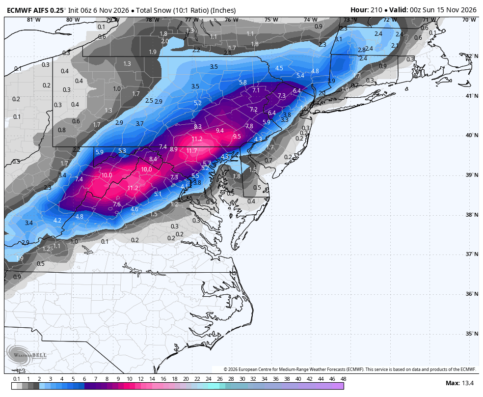
The X Weather Police are going to get me for this one! 😁 While it's rainy, muggy and mild around Baltimore today, next weekend could feel like winter. Most of the modeling agrees on a big chill for the Mid Atlantic in about 7-8 days. But the Euro AIFS takes it a step further and produces a big snow event! 👇 Now, do I think this is likely to happen? NO. But don't be surprised if some of you see the first snowflakes of the season. Stay tuned...❄️🚂
🇺🇸DC🍁Storms retweeted
Big Weatherbell.com Post on the crucial difference between a broad brush Strong nino idea and the mitigating circumstances this year. December is vastly different for instance Buckle up. Going to be a rollicking winter


